Browse Basin CO2 Storage Project
Page last updated:21 July 2016
Overview
A regional assessment of the geological carbon dioxide (CO2) storage potential of the Browse Basin, offshore northwest Australia was completed by Geoscience Australia between 2013 and 2016. The assessment was part of the Australian Government's National CO2 Infrastructure Plan (NCIP) to accelerate the identification and development of suitable areas for long-term CO2 storage proximal to major emission sources. The Browse Basin was selected, along with two other offshore sedimentary basins (Vlaming Sub-basin of the Perth Basin and Gippsland Basin) and onshore basins in Western Australia and New South Wales, for pre-competitive data acquisition and geological studies as part of this national assessment.
The Browse Basin is a proven hydrocarbon province that hosts significant reserves of gas and condensate, with the majority of accumulations being characterised by high concentrations of CO2 (Figure 1). The last comprehensive publicly-funded regional-scale geological study of the basin was the Browse Basin High Resolution (BBHR) study released by the Australian Geological Survey Organisation (AGSO, now Geoscience Australia) in 1997. Since then, new industry data have been acquired and several CO2 storage site feasibility studies have added to the geological knowledge of the basin.
This study assessed the CO2 storage potential of the basin in the context of existing hydrocarbon prospectivity. As the bulk of commercial hydrocarbon accumulations are hosted within the Jurassic and lowermost Cretaceous successions, this study focused on the Cretaceous succession where there is a reduced risk of overlap between CO2 storage and hydrocarbon resources.
The data used for this study includes information from over 60 wells, regional 2D and 3D seismic reflection surveys, potential field data, as well as existing and newly acquired pre-competitive geochemical, aeromagnetic (Figure 2) and marine environmental data. A revised tectonostratigraphic framework for the basin, standardised to the Geologic Timescale Scale 2012, was a major output of this study (Figure 3).
Regional structure
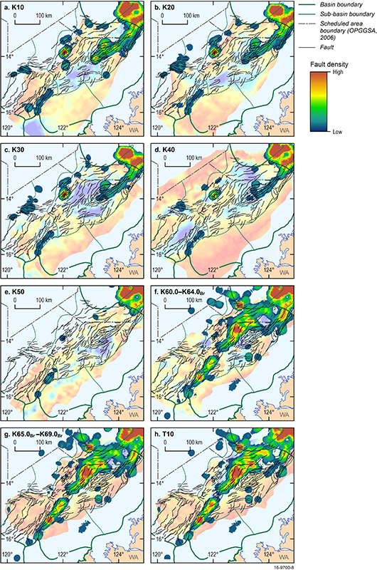
Regional-scale structural mapping of the Browse Basin included faults associated with major rifting events in the Carboniferous-Permian and Early-Middle Jurassic, Late Triassic compression and inversion, and a period of minor extension in the Late Jurassic-Early Cretaceous. More recent faulting related to the Neogene-Quaternary collision between the Australian and Eurasian tectonic plates was also mapped (Figure 4). The distribution of deep faults revealed different structural styles between the Barcoo and Caswell sub-basins, from multiple relatively small displacement faults in the Barcoo Sub-basin, to fewer large displacement fault systems in the Caswell Sub-basin.
Cretaceous sequence stratigraphy
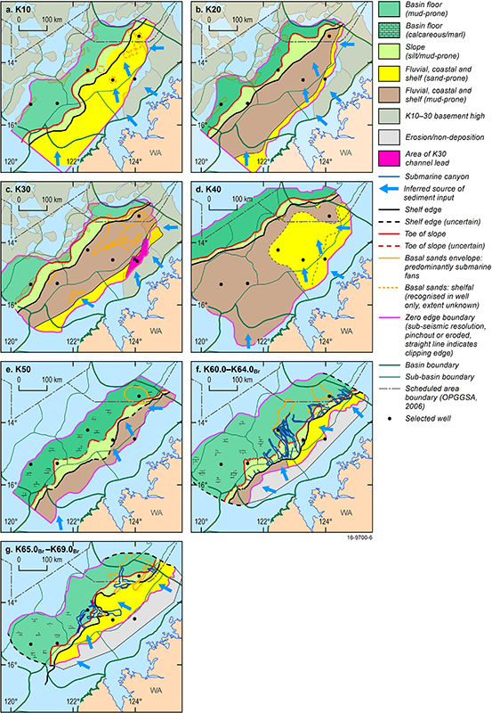
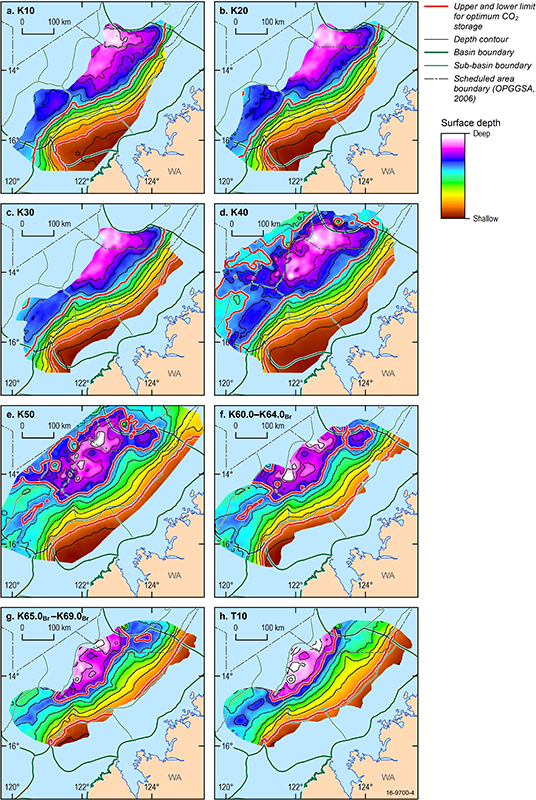
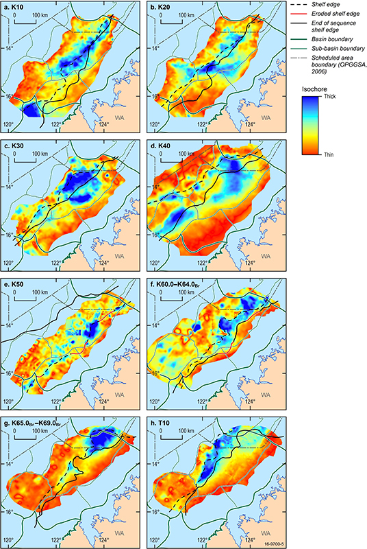
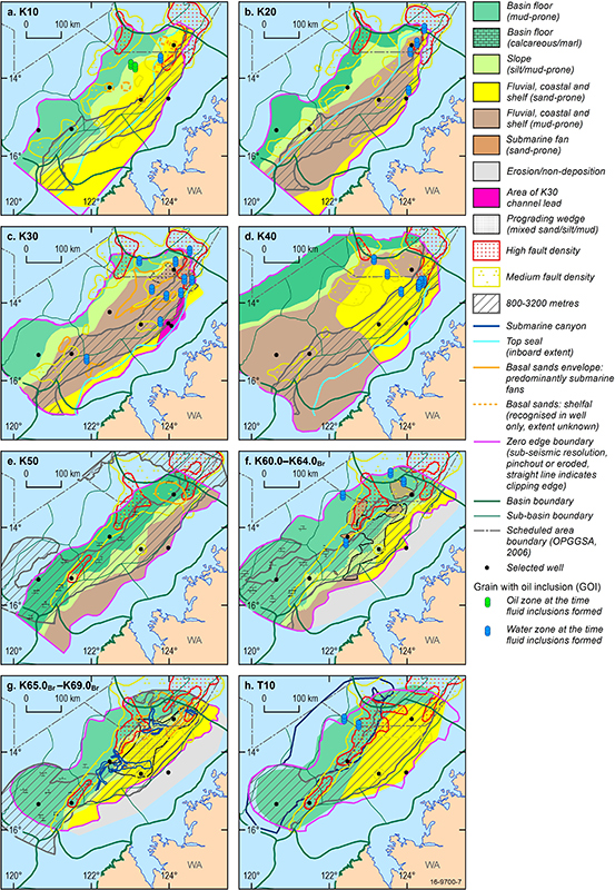
This study builds on previous work to improve the regional sequence stratigraphic framework for the Cretaceous interval. The K10-K60 supersequences, and the interval comprising the T10, T20 and T30 (part) supersequences, were mapped. Sequence cross-sections and palaeogeographic maps (Figure 5) were produced for the Cretaceous interval to show the distribution of gross depositional facies (GDF). Interpretation of GDF was based on seismic stratal geometries supported by well lithology, well log signature, and seismic facies. Horizon depth maps (Figure 6) and isochore maps (Figure 7) were also produced.
CO2 containment constraints and play fairway mapping
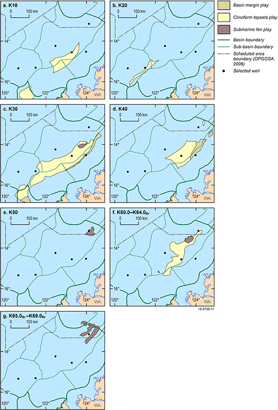
Supersequence cross-sections and palaeogeographic maps revealed three main stratigraphic play types across the Browse Basin: basin-margin, clinoform topset and submarine fan. Basin-margin plays occur throughout the Cretaceous succession where clinoform topsets merge and onlap landward. Clinoform topset plays extend between the basin-margin play and the supersequence shelf edge. The submarine fan plays comprise sandstone-prone basin-floor fans that extend from the toe of slope to the basin floor. The arrangement of reservoir and seal pairs within these play types is the principal constraint on geological CO2 storage.
Other constraints were reservoir depth range, fault distribution (Figure 8), and hydrocarbon resource overlap. Reservoirs within the optimal depth window for economic geological CO2 storage of 800-3200 metres are associated with the K10-K60 supersequences. Structural mapping revealed that deep regional faults provide potential conduits for hydrocarbon charge from Jurassic and deeper petroleum systems along the Heywood Fault System, resulting in potential risk for overlap with the Lower Cretaceous (K10-K40) CO2 storage plays. Plays in the Upper Cretaceous (K60) succession are affected, in part, by Neogene-Quaternary faulting that is optimally orientated for reactivation under the present-day regional stress regime, therefore posing a significant risk to seal integrity. New geochemical analyses have revised the extent and effectiveness of petroleum systems within the Cretaceous succession. Potential overlaps between CO2 storage and hydrocarbon resources have been identified on the Yampi Shelf and in the northern part of the Caswell Sub-basin particularly in association with the K10 supersequence. Containment constraints were mapped for each supersequence to produce play fairway maps (Figure 9).
Common risk element mapping
Composite common risk element maps were compiled by the application of criteria-based traffic-light colour coding of play fairway maps (red=unsuitable, orange=moderately suitable, green=highly suitable). Plays identified as moderately suitable for CO2 storage occur within: 1) K10, K20, K30, lower K40, and K60 clinoform topset plays, 2) K10-K40 stacked basin-margin plays, and 3) K30, K50, and K60 submarine fan plays (Figure 10). Highly suitable plays were not identified by this regional assessment. This outcome is in part because of the current uncertainty about any remaining hydrocarbon prospectivity in the basin.
Outcomes
This study provides a revised basin framework and a regional-scale preliminary prospectivity assessment for the geological storage of CO2 in the Browse Basin. The results will guide future, targeted, site-specific assessments, and identify the main geologic risks warranting further investigation. The study findings will also assist in reducing the risk of overlap between CO2 storage and hydrocarbon resources.
References
AGSO Browse Basin Project Team, 1997. Browse Basin High Resolution Study, Interpretation Report. Record 1997/38. Australian Geological Survey Organisation, Canberra
Gradstein, F.M., Ogg, J.G. & Schmitz, M.D., 2012. The Geologic Time Scale 2012. Elsevier BV, Boston, USA. 1144 pp.
Kelman, A.P., Khider, K., Rollet, N., Abbott, S., Grosjean, E. & Lech, M., 2016. Browse Basin Biozonation and Stratigraphy, Chart 32. Geoscience Australia.
Marshall, N.G. & Lang, S.C., 2013. A new sequence stratigraphic framework for the North West Shelf, Australia. In: Keep, M. & Moss, S.J. (eds.) The Sedimentary Basins of Western Australia 4: Proceedings of Petroleum Exploration Society of Australia Symposium. Petroleum Exploration Society of Australia, Perth. 1-32.


