North Australia Project: Tanami seismic research
Page last updated:8 April 2016
The North Australia Project concluded on 30 June 2006.
Project description
The Tanami Seismic Research Project aimed to understand both the crustal architecture and mineral systems of the Tanami region by using deep seismic reflection techniques. The project involved Geoscience Australia, the Geological Survey of Western Australia, the Northern Territory Geological Survey, Newmont Exploration Pty Ltd and Tanami Gold NL.
Objectives
The objectives of the seismic survey were to:
- image the geometry of the main faults
- determine a deformation sequence to these fault structures
- identify any through-going crustal structures
- determine stratigraphic thicknesses of the Tanami Group and granite body geometries
- determine relationships of the various stratigraphic packages to controlling structures
- investigate the relationship of mineralised domains to crustal scale structures
- identify Archean basement and its relationship to the overlying Tanami Group stratigraphy.
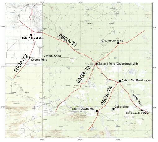
The survey consisted of four regional seismic traverses (05GA-T1 through 05GA-T4: Figure 1). Traverse 05GA-T1 was a northwest-southeast regional transect. Traverses 05GA-T2, 05GA-T3 and 05GA-T4 provided orthogonal three-dimensional control on the geometry of the region's main fault systems. In addition, the project collected gravity data every 400m along the seismic traverses as well as wide-angle velocity data along the regional traverse 05GA-T1.
The results were presented at the project wrap-up conference, Evolution and metallogenesis of the North Australian Craton, held in Alice Springs, Australia in June 2006 and also published in Goleby et al. (2008, Tectonophysics, v. 472, pp. 169-182).
Methodology
Seismic data were acquired between April and July in 2005. The seismic traverses were designed to run close to the Coyote, Tanami, Groundrush and Callie mine sites to provide information on the deeper structures in these areas. Three IVI Hemi 60 vibrators were used, with a vibration point interval of 80m, a geophone group interval of 40m, and a 240 channel split spreat, resulting in 60-fold data to at least 20s two way time. Characteristics of each seismic line are presented in Table 1. The data were processed using methods developed for land seismic surveys at Geoscience Australia, and the results were interpreted in a series of workshops held in 2006 and 2007 that involved all participants in the project. Each traverse was interpreted independently by at least three groups during the workshops. Following discussions within the project, the individual interpretations were combined into a final interpretation, which was checked using forward modelling of the gravity data collected during the survey and regional aeromagnetic data.
Table 1. Seismic acquisition, Tanami project
| Traverse | Nominal line length (km) | Final line length (km) | Quality of data |
|---|---|---|---|
| 05GA-T1 | ~354 | 354.28 | Field data very good. |
| 05GA-T2 | ~110 | 101.8 | Field data very good. |
| 05GA-T3 | ~190 | 179.24 | Field data very good. |
| 05GA-T4 | ~90 | 84.4 | Field data very good. |
Results and interpretations
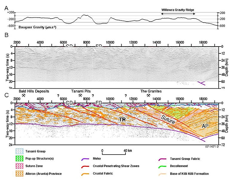
Figure 2 shows uninterpreted and interpreted sections for traverse 05GA-T1. The seismic interpretation identified:
- A major crustal boundary between the Tanami Province to the north and the Aileron Province to the south. This boundary is characterised by a change in seismic character, and major increase in crustal thickness as indicated by the depth of the Moho, and a crocodile-like geometry.
- A stratigraphic package that thins in general from northwest to southeast, although with significant local changes in thickness. This stratigraphic package is interpreted to overly the above crustal boundary and corresponds at surface to the Tanami Group in the Tanami Province and the Lander Rock beds in the Aileron Province.
- A series of northwest-dipping crustal-penetrating shear zones that offset the upper stratigraphic package, which, in some cases, thickens against these shear zones. In some cases, the shear zones are associated with hanging wall anticlines.
These geometrical relationships are interpreted to to indicate:
- A suture between the Aileron Province to the south and the Tanami Province to the north. The surface expression of this suture corresponds to the northern margin of the Willowra Gravity Ridge, which is can be used to trace this suture to the east and west. This gravity feature is interpreted to be the consequence of high density rocks within the wedge that forms part of the suture. The suture is overlain by the Tanami Group-Lander Rock beds package, which has an age of between 1860 and 1840 Ma, providing a minimum age for juxtaposition of the Tanami and Aileron Province.
- The crustal-penetrating shears are interpreted as original extensional faults that formed during the development of the Tanami-Lander Rock basin and were subsequently inverted during later deformation, possibly during the Tanami or Safford Events. Structures formed and reactivated during these extensional and contractional events became sites of fluid flow and gold deposition during the later Tanami gold event.

