Tsunami
Page last updated:6 February 2025
What is a tsunami?
Tsunami (pron: 'soo-nar-me') is a Japanese word: 'tsu' meaning harbour and 'nami' meaning wave. Tsunami are waves caused by sudden movement of the ocean surface due to earthquakes, landslides on the sea floor, land slumping into the ocean, large volcanic eruptions or meteorite impact in the ocean.
Until recently, tsunami were called tidal waves, but this term is generally discouraged because tsunami generation has nothing to do with tides (which are driven by the gravity of the Earth, Moon and Sun). Although some tsunami may appear like a rapidly rising or falling tide at the coast, in other situations they can also feature one or more turbulent breaking waves.
How do tsunami differ from regular waves?
A tsunami is different from a wind-generated surface wave on the ocean. While wind-generated waves in the deep ocean only cause water movement near the surface, a tsunami involves the movement of water from the surface to the seafloor. Interestingly this causes the speed of a tsunami to be controlled by the water depth, with faster speeds in deeper water. Consequently, a tsunami slows as it approaches land and reaches increasingly shallow water, which causes the distance between successive wave peaks to decrease as well. Because the total energy within the wave does not change, the energy is transferred to increasing the wave height (or amplitude). This is called wave shoaling.
A tsunami is often a series of waves and the first may not necessarily have the greatest amplitude. In the open ocean, even the largest tsunami are relatively small, with wave heights typically tens of centimetres or less away from the initial tsunami generation zone. Higher oceanic wave heights often occur very close to the tsunami generation zone and are sometimes observed (e.g., deep oceanic waves near two metres were measured close to the source of the 2011 Japan tsunami). In any case, the shoaling effect can greatly increase open ocean wave heights upon reaching the coast, with some tsunami reaching an onshore height more than ten metres above sea level. Such extreme inundation is more likely to occur nearer to the tsunami generation location (where oceanic wave heights are larger), and at locations where the coastline shape is particularly favourable to tsunami amplification. Most tsunami do not cause such extreme coastal inundation, and the effect of small events may not be noticeable to without careful analysis of tide gauge measurements.
What causes tsunami?
Earthquakes
75% of tsunami have been caused by large earthquakes on the sea floor when slabs of rock move past each other suddenly, causing the overlying water to move. The resulting waves move away from the source of the earthquake event.
Landslides
Landslides can happen on the seafloor, just like on land. Areas of the seafloor that are steep and loaded with sediment, such as the edge of the continental slope, are more prone to undersea landslides.
When an undersea landslide occurs (perhaps after a nearby earthquake) a large mass of sand, mud and gravel can move down the slope. This movement will draw the water down and may cause a tsunami that will travel across the ocean.
Volcanic eruptions
Tsunami initiated by volcanic eruptions are less common. They occur in several ways:
- destructive collapse of coastal, island and underwater volcanoes which result in massive landslides
- pyroclastic flows, which are dense mixtures of hot blocks, pumice, ash and gas, plunging down volcanic slopes into the ocean and pushing water outwards
- a caldera volcano collapsing after an eruption causing overlying water to drop suddenly.
- Resonance of the ocean and atmospheric pressure waves caused by a large volcanic explosion
Where do tsunami occur in Australia?
There is evidence that the Australian coast may have experienced large tsunami during the past few thousand years. This evidence is revealed through anomalous sedimentary deposits (such as those containing shell or coral) or other geomorphic features (Dominey Howes, 2007, Goff and Chauge-Goff, 2014). More recently, tsunami continue to be recorded in Australia with most presenting little threat to coastal communities. The significant tsunamis recorded in recent times have all been recorded at tide gauges around the country with some causing damage in the marine environment.
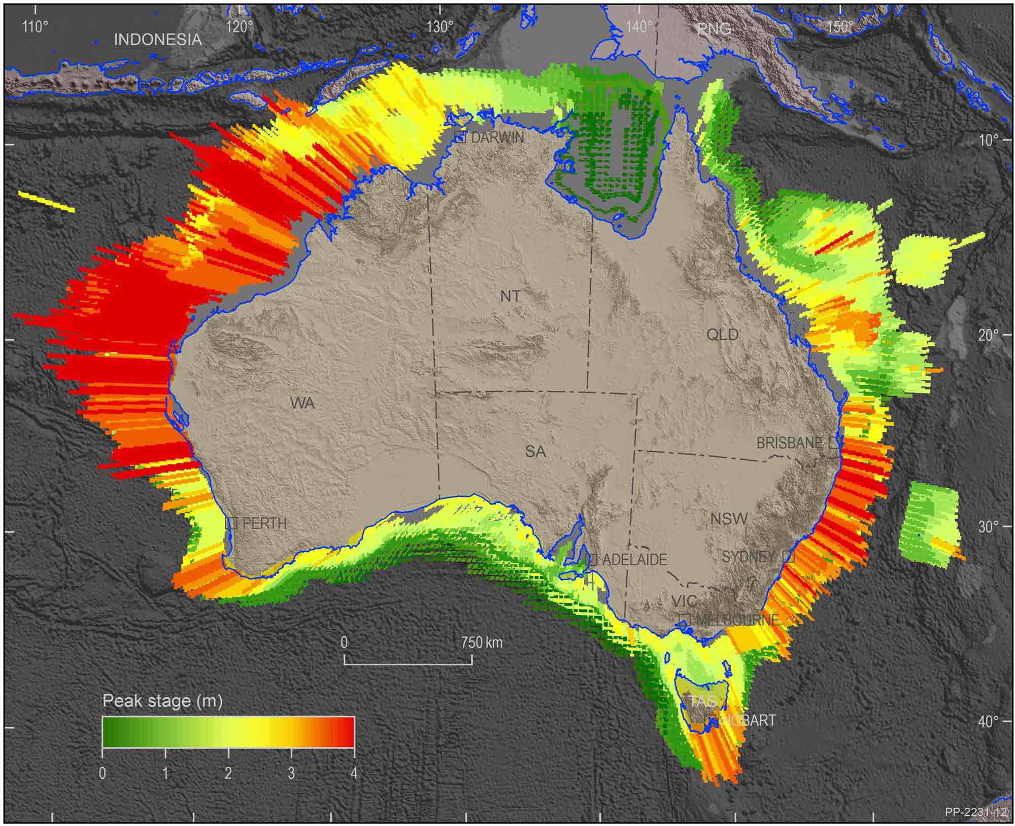
The tsunami hazard faced by Australia ranges from relatively low along the southern coasts of Australia to moderate along the west coast of Western Australia. This area is more susceptible because of its proximity to large subduction zones along the south-coast of Indonesia, which is a region of significant earthquake and volcanic activity.
Several significant tsunami have impacted Australia's north west coast region. The largest run-up (measured as elevation above sea level) was recorded as 7.9m (Australian Height Datum (AHD)) at Steep Point in Western Australia from the July 2006 Java tsunami. The largest reported offshore wave height was six metres near Cape Leveque from the August 1977 Sunda tsunami.
Our role
Reducing risk to Australians from tsunami
Geoscience Australia is committed to support Australia's capability to manage the impact of natural hazards, including tsunami.
Geoscience Australia:
- develops an understanding of natural hazards and community exposure to support risk mitigation and community resilience
- provides authoritative, independent information and advice to the Australian Government and other stakeholders to support risk mitigation and community resilience
- maintains and improves systems for effective natural disaster preparedness, response and recovery
- contributes to Australia's overseas development program.
To learn more about our work, access our latest data or hazard assessment tools, visit the Community Safety page.

