NTDB & NTMS Specifications (250K & 100K)
|
Updated: 1 December 2007
2.4 Infrastructure
2.4.1 Fences
| |
|---|
| Location of Example: |
25°17'49" South, 152°38'43" East |
| Distinctive Characteristics: |
- Fences tend to be depicted as narrower features than roads. They generally form polygonal shapes, outlining paddocks and properties. They also tend to cut across properties unlike roads.
- The fences stand out as a narrower band of lighter blue as opposed to the thicker darker signature of the roads.
- Fences generally enclose property boundaries or internal paddocks but do not provide connectivity or access to the farm infrastructure, i.e. Homesteads, Buildings, Water Tanks, etc.
|
| Regional Considerations: |
|
| Figure: 2.4.1.1 Representation of Fences Vs Roads. |


[back to top]
2.4.2 Water Towers
2.4.2.1 Example 1
| |
|---|
| Location of Example: |
152°20'25" East, 24°51'04" South |
| Distinctive Characteristics: |
- Water Towers appear as circular elevated features. This is evident by the shadow signature.
- Water Tanks/Water Towers are typically found in residential/urban areas, unlike Storage Tanks which are typically found in industrial/commercial areas.
- Water Tanks/Water Towers tend to be solitary, unlike Storage Tanks that are typically concentrated in one area.
|
| Regional Considerations: |
|
| Figure: 2.4.2.1 Representation of a Water Tower in association with surrounding features. |


[back to top]
2.4.2.2 Example 2
| |
|---|
| Location of Example: |
| Distinctive Characteristics: |
- Water Towers are of various constructions as per Figure: 2.4.2.2.
- Water Towers are typically located within or nearby Population Centres, they are significant topographic features because of their height.
|
| Regional Considerations: |
|
| Figure: 2.4.2.1 Photographs of Water Towers. |


[back to top]
2.4.3 Storage Tanks
2.4.3.1 Example 1
| |
|---|
| Location of Example: |
152°50'43" East, 25°17'16" South |
| Distinctive Characteristics: |
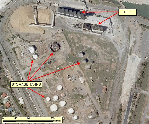
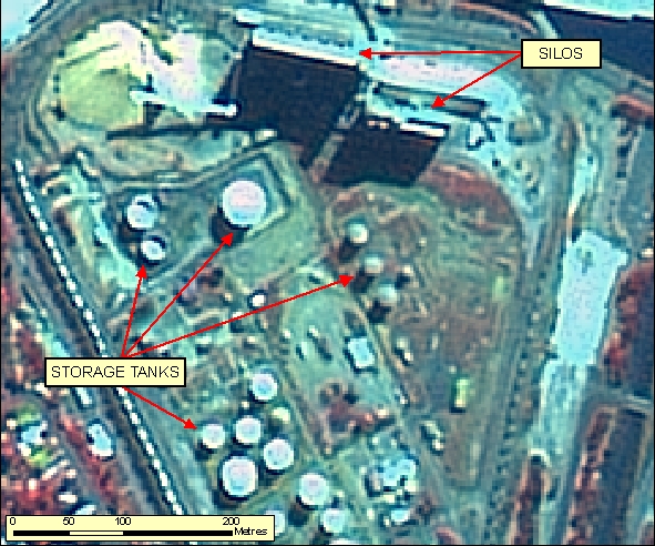
- Storage Tanks appear as circular elevated features, this is evident by the shadow signature.
- Storage Tanks may or may not have an enclosed roof.
- Storage Tanks can sometimes be distinguished from Water Tanks/Water Towers because they are typically found in industrial/commercial areas rather than within residential/urban areas.
- Numerous Storage Tanks are typically concentrated in one area, whereas Water Tanks/Water Towers tend to be more solitary.
|
| Regional Considerations: |
|
| Figure: 2.4.3.1 Representation of Storage Tanks in association with surrounding features. |


[back to top]
2.4.3.2 Example 2
| |
|---|
| Location of Example: |
152°23'05" East, 24°46'03" South |
| Distinctive Characteristics: |
- Storage Tanks appear as circular elevated features, this is evident by the shadow signature.
- Storage Tanks may or may not have an enclosed roof.
- Storage Tanks can sometimes be distinguished from Water Tanks/Water Towers because they are typically found in industrial/commercial areas rather than within residential/urban areas.
- Numerous Storage Tanks are typically concentrated in one area, whereas Water Tanks/Water Towers tend to be more solitary.
|
| Regional Considerations: |
|
| Figure: 2.4.3.2 Representation of a Storage Tanks in association with surrounding features. |


[back to top]
2.4.3.3 Example 3
| |
|---|
| Location of Example: |
151°14'45" East, 27°10'52" South |
| Distinctive Characteristics: |
- Storage Tanks appear as circular elevated features, this is evident by the shadow signature.
- Storage Tanks may or may not have an enclosed roof.
- Storage Tanks can sometimes be distinguished from Water Tanks/Water Towers because they are typically found in industrial/commercial areas rather than within residential/urban areas.
- Numerous Storage Tanks are typically concentrated in one area, whereas Water Tanks/Water Towers tend to be more solitary.
|
| Regional Considerations: |
|
| Figure: 2.4.3.3 Representation of Storage Tanks in association with surrounding features. |


[back to top]
2.4.3.4 Example 4
| |
|---|
| Location of Example: |
151°15'27" East, 23°50'6" South |
| Distinctive Characteristics: |
- Storage Tanks appear as circular elevated features, this is evident by the shadow signature.
- Storage Tanks may or may not have an enclosed roof.
- Storage Tanks can sometimes be distinguished from Water Tanks/Water Towers because they are typically found in industrial/commercial areas rather than within residential/urban areas.
- Numerous Storage Tanks are typically concentrated in one area, whereas Water Tanks/Water Towers tend to be more solitary.
- Storage Tanks may be distinguished from Silos by their flat roof structure compared with a conical roof structure of a Silo.
- The roof of a Storage Tank may show temporal change due to the amount of product stored in the Tank when the imagery was captured.
|
| Regional Considerations: |
|
| Figure: 2.4.3.4 Representation of Storage Tanks in association with surrounding features. |


[back to top]
2.4.4 Mine Areas
2.4.4.1 Example 1
| |
|---|
| Location of Example: |
152°28'10" East, 24°51'33" South |
| Distinctive Characteristics: |
- Sand/gravel quarries consist of a series of small to medium sized pits.
- Infrastructure associated with quarries varies according to size and ownership. Small quarries used for intermittent road repairs and owned by local government authorities are not likely to have much associated infrastructure. Large commercial operations close to large cities are more likely to have extensive crushing, stockpiling and administrative facilities.
|
| Regional Considerations: |
|
| Figure: 2.4.4.1 Representation of a Mine Area in association with surrounding features. |


[back to top]
2.4.4.2 Example 2
| |
|---|
| Location of Example: |
151°59'9" East, 27°56'9" South |
| Distinctive Characteristics: |
- Hard rock quarries are typically sited in foothills flanking urban and peri-urban centres.
- Hard rock quarries are generally composed of one main medium-sized pit and excavated into a hillside.
- The excavation depth is evident by terracing and it's associated shadow signatures.
- In Figure: 2.4.3.2b the spectral signature of the bedrock is dark blue/grey. This should be similar to the spectral signature of rocky slopes and outcrops devoid of vegetation.
|
| Regional Considerations: |
|
| Figure: 2.4.4.2 Representation of a Mine Area in association with surrounding features. |


[back to top]
2.4.4.3 Example 3
| |
|---|
| Location of Example: |
151°15'29" East, 27°56'42" South |
| Distinctive Characteristics: |
- Open cut mines are usually metalliferous or coal mines.
- Open cut mines are generally quite large compared with quarries and underground mines.
- Large open cut mine features are usually located away from settled areas and are often associated with extensive surface infrastructure, such as processing facilities, stockpiles, haul roads, settling ponds, power lines, mine accommodation villages, transport facilities.
- In Figure: 2.4.4.3b the spectral signature of the land disturbance is light blue/grey compared with the surrounding land and vegetation that is red/brown.
|
| Regional Considerations: |
|
| Figure: 2.4.4.3 Representation of a Mine Area in association with surrounding features. |


[back to top]
2.4.4.4 Example 4
| |
|---|
| Location of Example: |
151°15'29" East, 27°56'42" South |
| Distinctive Characteristics: |
- Sand/gravel quarries consist of a series of small to medium sized pits.
- Infrastructure associated with quarries varies according to size and ownership. Small quarries used for intermittent road repairs and owned by local government authorities are not likely to have much associated infrastructure. Large commercial operations close to large cities are more likely to have extensive crushing, processing, stockpiling and administrative facilities.
- Interpretation of components within complex Mine Areas is difficult from imagery alone. Use additional Reference Material where available or seek further clarification from Geoscience Australia via Action Request.
- As illustrated in Figure 2.4.4.4 there may be a temporary presence of water in a Mine Area. The mine acts as it´s own catchment. These temporary catchments should not be captured as a water body area.
|
| Regional Considerations: |
|
| Figure: 2.4.4.4 Representation of a Mine Area in association with surrounding features. |


[back to top]
2.4.4.5 Example 5
| |
|---|
| Location of Example: |
150°53'48" East, 32°11'34" South |
| Distinctive Characteristics: |
- Figure 2.4.4.5 is an example of a complex Mine Area.
- Interpretation of components within complex Mine Areas is difficult from imagery alone. Use additional Reference Material where available or seek further clarification from Geoscience Australia via Action Request.
|
| Regional Considerations: |
|
| Figure: 2.4.4.5 Representation of a complex Mine Area. |

|
