News
Continental mapping uncovers Australia’s hidden geology
Published:14 August 2024
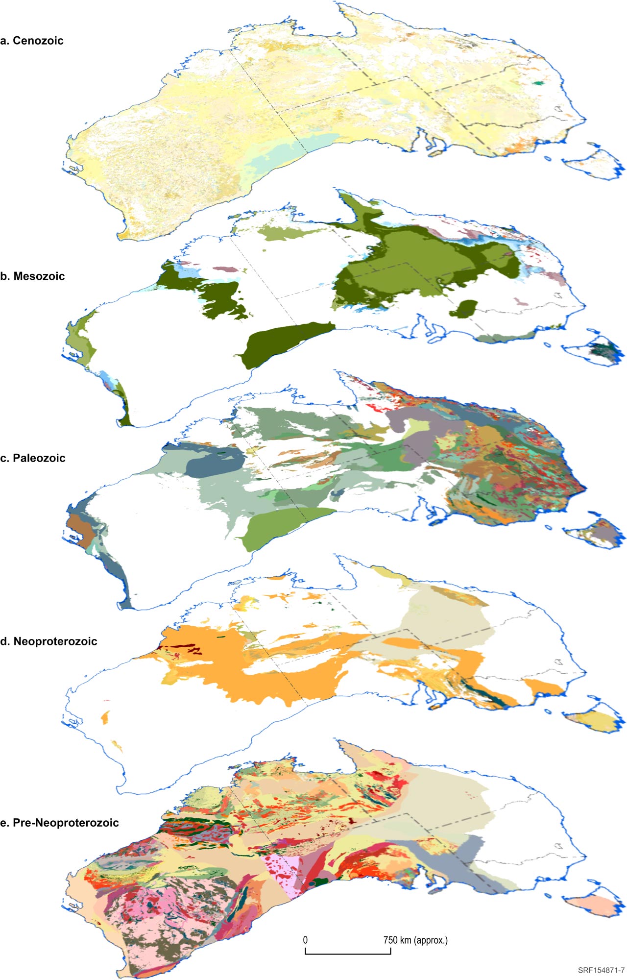
A new map has been released by Geoscience Australia, showing a layered view of Australia’s surface and subsurface geology by progressively stripping away geological layers up to 1 billion years old.
Delivered under the Exploring for the Future program, the Layered Geology of Australia introduces a new era of geological mapping, marking a significant advancement from previous national surface geology maps.
It details the geology of five major eras, ranging in age from the Cenozoic – younger than 66 million years ago – to the pre-Neoproterozoic – older than 1,000 million years ago, layered on top of each other. Users can remove or add the layers to uncover details of the geology of each era.
“Accurate mapping of Australia’s rocks is vital to managing our mineral, energy and groundwater resources,” Chief of Minerals, Energy and Groundwater Division at Geoscience Australia, Dr Andrew Heap, said.
“With up to 80% of Australia’s surface covered by sediments, it can be challenging to map what lies beneath.
“The Layered Geology of Australia reveals what is underneath those top layers that we live and walk on.”
Understanding what is in these hidden layers is crucial in understanding groundwater resources, identifying hydrogen storage potential and exploring for deposits of critical minerals and strategic materials that will be critical to Australia’s future prosperity and transition to net zero carbon emissions.
Compiled using existing geology maps, information from drill holes and interpretations of geophysical datasets that image the subsurface, scientists built a comprehensive overview of the entire continent at a scale of about 1:1,000,000. Working in partnership with the state and Northern Territory geological surveys reconciled differences in geological understanding and interpretation at the regional scale to produce national-scale seamless layers.
Dr Heap said that no other country currently has a layered national dataset like the Layered Geology of Australia.
“It is a world-first for harmonised continental-scale geological mapping,” he said.
“Traditionally we’ve had to rely on surface geology, which provides a limited view of Australia’s geology, so to be able to see beneath the surface and then also through time is significant.
“In essence, the Layered Geology of Australia is a globally significant advance in geological mapping, helping to reveal Australia’s potential for additional mineral, energy and groundwater resources like never before, and will inform natural resource management across Australia.”
The Layered Geology Map of Australia is available here.