News
Landsat informing better wetland management in Australia and Africa
Published:24 July 2024
Learning from the past to plan for a better future: Supporting nature-based climate change solutions through Earth observation
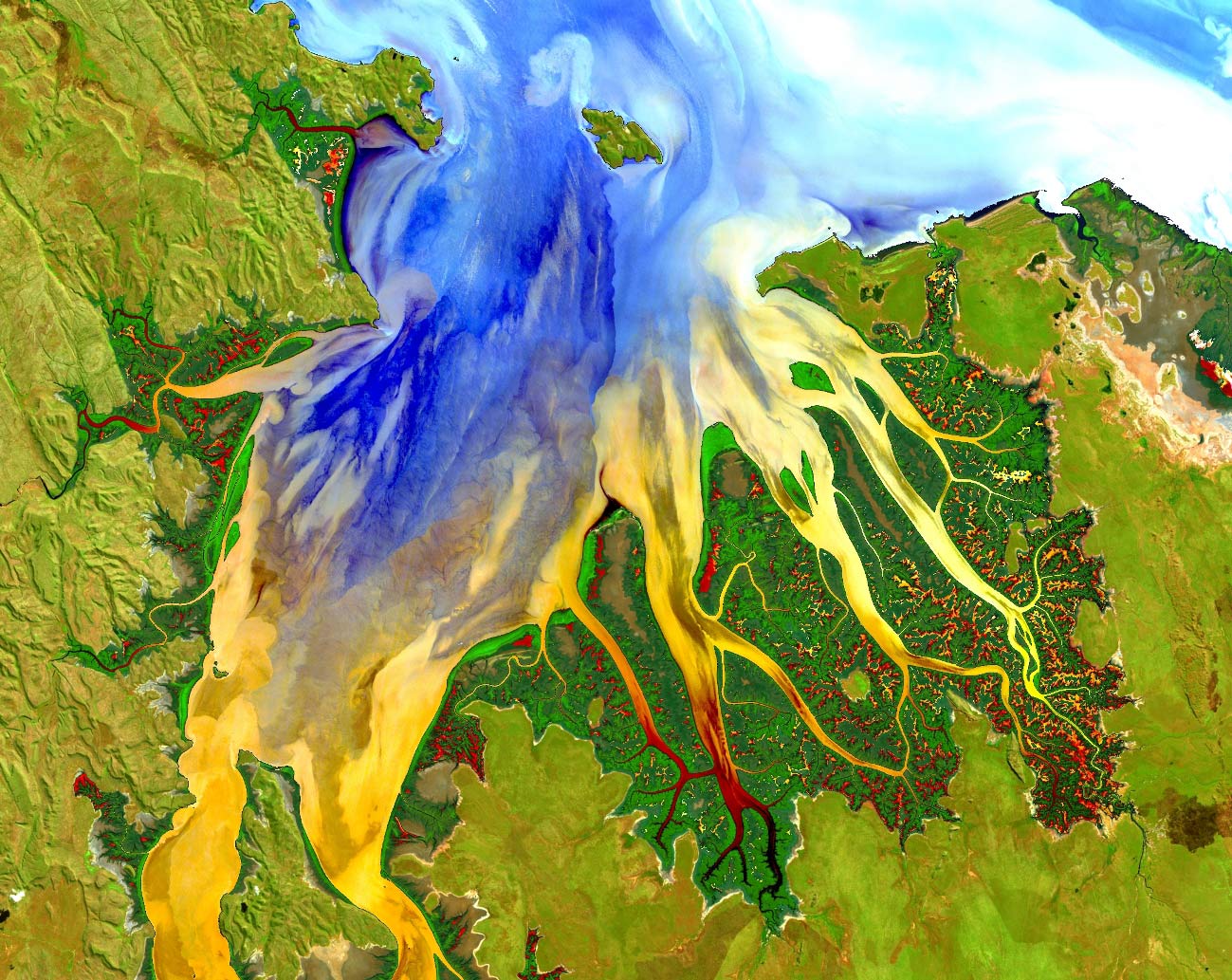
Mangroves and estuarine eddies of the Cambridge Gulf, on the north coast of Western Australia's Kimberley region, DEA Surface Reflectance, processed by Digital Earth Australia
When facing a challenge like climate change, looking to nature can provide us with some uniquely robust and effective mitigation and adaptation techniques, known as ‘nature-based’ climate solutions. It is estimated that nature-based climate solutions could provide 37% of the mitigation required to achieve the targets of the Paris Agreement in 2030. They also play a key role in climate change adaptation and building resilience in landscapes and communities.
Nature-based climate solutions have many positive effects on human well-being and biodiversity, as well as helping to address food and water security, and reducing the impact of natural disasters.
Mangroves and freshwater wetlands are two examples of precious ecosystems that provide nature-based solutions to climate change and a range of benefits for the environment and human populations.
Planting mangroves in coastal areas buffers the coastline against erosion and storm surges, protecting local communities from flooding. Mangroves also store carbon (carbon sequestration) and provide an ecosystem for local wildlife and other plants.
Wetlands hold excess water which can help to reduce the impact and overall risk of flooding, particularly in urban areas. Providing natural filtration, wetlands absorb pollution and maintain water quality and sanitation for local communities. In addition to storing carbon, the plants and soils in these diverse ecosystems provide natural stabilisation of the external temperature through heating and cooling.
But how do we know how to manage our freshwater wetlands and mangroves to make these strategies the most effective? One of the ways we can do this is by using satellite imagery. Since the 1970s, NASA and the United States Geological Survey have used Landsat satellites to capture imagery about our environment, but using this collective information was a challenge. In 2018, Geoscience Australia launched Digital Earth Australia (DEA), harnessing over 35 years of this archive, enabling us to view changes and trends over time. Digital Earth Africa, built on DEA technology, has been operating since 2019 to provide these benefits to the African continent.
The Wetlands Insight Tool and Mangrove Canopy Cover data use Landsat data and Digital Earth technologies to help understand the current condition of wetlands, the extent of the vegetation and how these have changed over time. These tools can also be layered with other data such as rainfall, climate, water observations and satellite imagery to help identify what might affect the changing condition and extent of freshwater wetlands and mangroves. This is powerful information to help decision makers protect and restore these ecosystems, enabling more nature-based climate solutions.
Protecting the world’s wetlands
Digital Earth Australia’s Wetlands Insight Tool (QLD) (DEA WIT) and Digital Earth Africa’s Wetlands Insight Tool (DE Africa WIT) visualise wetlands by showing how the amounts of water, green vegetation, dry vegetation and bare soil have changed since 1987. They can help decision makers, researchers and private industry to conduct climate impact assessments. This includes agriculture drought monitoring, ecological drought monitoring, sustainable water use, and land degradation assessments.
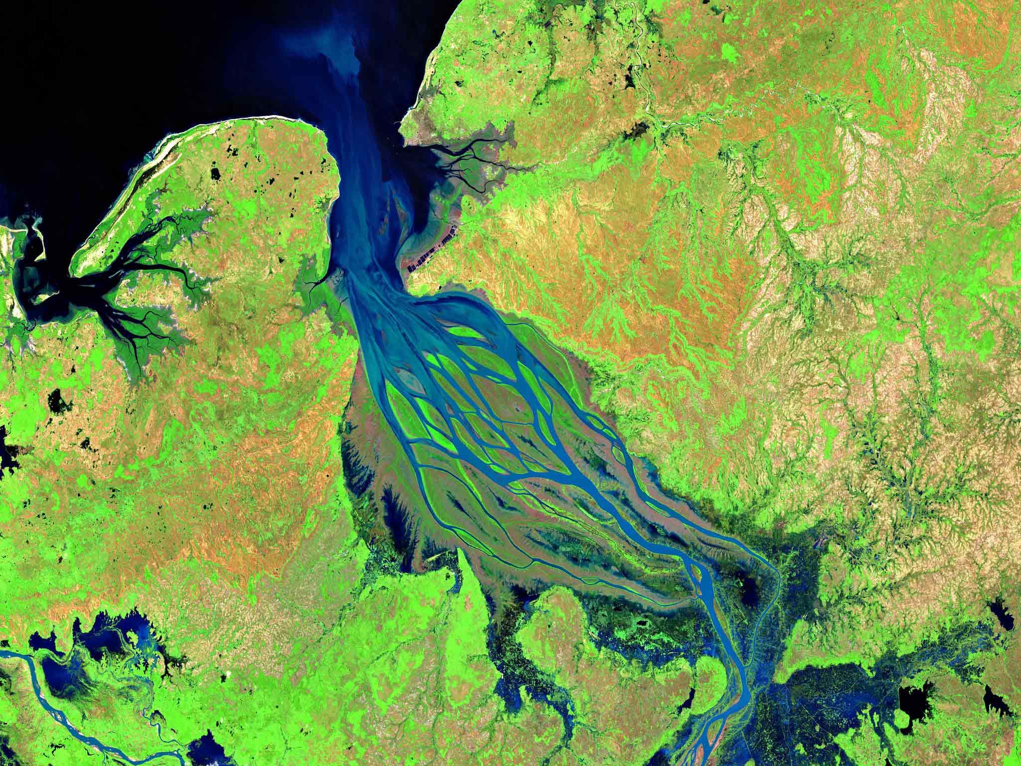
Betsiboka Estuary Madagascar, Sentinel2 2020, processed by Digital Earth Africa
Despite their importance, the majority of wetland resources globally have been lost - we cannot achieve global biodiversity, climate, or sustainable development goals without addressing wetlands, and Earth Observation provides an essential information source to support managing and restoring these ecosystems.
Dr Lisa-Maria Rebelo, Lead Scientist, Digital Earth Africa
Sustainable wetlands management, Queensland, Australia
The QLD Department of Environment, Science and Innovation have been using the DEA WIT to inform the application of QLD state planning, management and decision making to support wetland conservation and management. Data and insights from the DEA WIT also facilitate the implementation of Queensland ’s Ramsar wetlands commitments, Protected Area Planning and the implementation of the Great Barrier Reef 2050 Wetlands Strategy by allowing us to more accurately characterise wetlands. It is now displayed on the QLD Government’s WetlandMaps.
The [DEA] WIT information, combined with the existing Queensland wetlands mapping is a really powerful combination. The outputs are used on a daily basis by a very broad range of stakeholders, from government officers to planners and to those involved in on-ground rehabilitation and management – frankly it’s hard to know how we managed without [the DEA WIT].
Mike Ronan, Manager Wetlands, Queensland Department of Environment, Science and Innovation
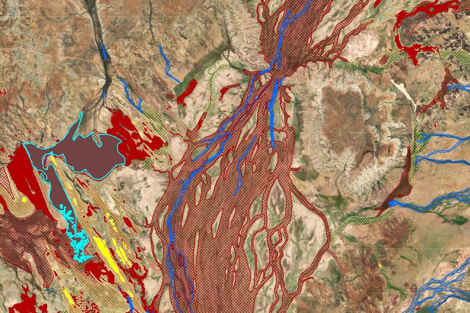
Screen capture of the Queensland WetlandMaps website for the landscape around the Diamantina National park in Queensland, for which DEA WIT data can be viewed for selected wetlands. WetlandMaps (des.qld.gov.au)
Nature-based climate solutions
Digital Earth Australia’s Mangrove Canopy Cover product tracks the extent and canopy density of mangroves, revealing how these extraordinary trees may be responding to sea level rise, severe tropical cyclones, drought, climatic cycles, changing temperatures and large storm events.
The DE Africa map allows users to monitor mangrove extent and visualise how the mangroves change over time using Global Mangrove Watch data. In a tailored notebook from the DE Africa Sandbox mangroves are classified using the Normalized Difference Vegetation Index (NDVI) and Normalized Difference Water Index (NDWI).
Fighting climate-change effects by mapping mangroves, Tanzania
On Zanzibar Island, located off the coast of Tanzania, the local government is using data and satellite imagery from Digital Earth Africa to inform how they manage mangroves, which provide local residents with valuable protection from storm surges and rising sea levels, making the whole area more resilient to a changing climate. Researchers and lecturers from the State University of Zanzibar (SUZA), Massoud Hamad and Raya Ahmada are using Digital Earth Africa’s data to inform how they conserve and restore mangroves. They are also building community awareness of the importance of mangroves in protecting the island from effects of climate change. The importance of Earth observation data and the community led climate actions were featured in an Amazon documentary series ‘Climate Next’ Episode 1: The essential mangrove.
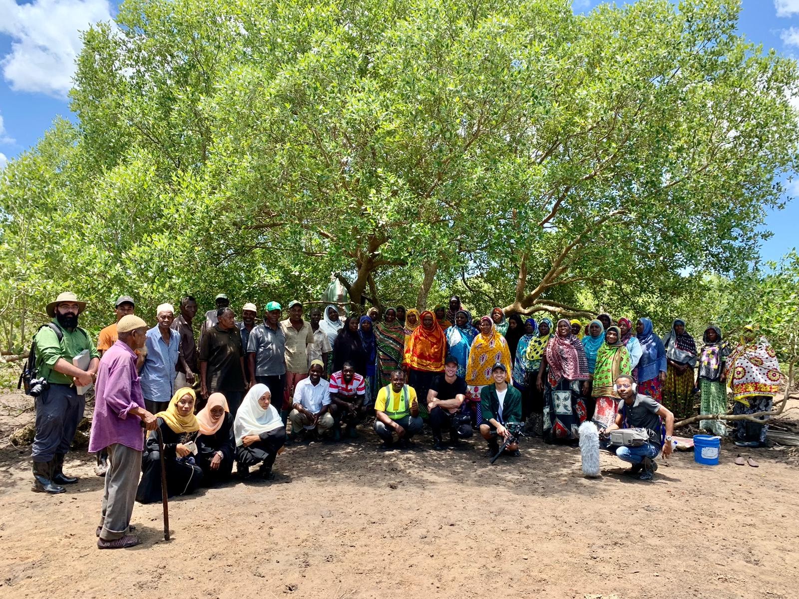
Researchers from SUZA and the local community in a local mangrove forest filming the Amazon Documentary
Planning for the future
As our climate continues to change, leading to a possible increase in extreme weather events, nature-based solutions will play an important role in climate action. Using Earth observation data and products such as DEA WIT and DE Africa WIT, decision makers, researchers and industry can better understand the importance of wetlands and mangroves. These insights can be used to make data-informed decisions to prevent risk to communities, delicate ecosystems and critical infrastructure.
How to get involved
More information about the Digital Earth Australia and Digital Earth Africa programs can be found via their websites.
For map-based access to DEA Water Observations, DE Africa Water Observations, DEA Water Bodies, DE Africa Water Bodies, as well as many other Landsat-based services, check out Digital Earth Australia Maps and Digital Earth Africa Map.
All DE Australia and DE Africa services can also be accessed through the free learning and analysis environments provided by the DEA and DE Africa Sandboxes. The Sandboxes include sample data and Jupyter Notebooks that allow you to experiment with DEA’s and DE Africa’s Earth observation datasets and explore proof-of-concept applications.
Visit https://app.sandbox.dea.ga.gov.au or https://sandbox.digitalearth.africa to sign up for a new account.
About Landsat
Since 1972, Landsat satellites have continuously acquired images of the Earth’s land surfaces, surface waters, and coastal regions, providing uninterrupted data to help land managers and policymakers make informed decisions about natural resources and the environment. The mission is jointly managed by the USGS and NASA. Data acquired by Landsat satellites are distributed from the USGS Earth Resources Observation and Science (EROS) Center in Sioux Falls, South Dakota.
Learn more about Landsat at https://www.usgs.gov/landsat and https://landsat.gsfc.nasa.gov
Learn more about Landsat Products at https://www.usgs.gov/landsat-missions/landsat-science-products