News
Australia's foundations revealed in a new atlas
Published:27 June 2014
Resource explorers, mining companies, researchers and the public will have improved opportunities to more closely investigate what geological structures lie beneath Australia with the release of an atlas of Australia's deep seismic reflection profiles.
In a joint venture between Geoscience Australia and the Australian National University, images of seismic reflection data that were collected over more than 30 years have been compiled into a single publication.
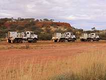
The data have been obtained in six Australian States and the Northern Territory using explosives and, more recently, Vibroseis vibrator trucks. Equipment on these vehicles transmits sound waves into the Earth, some of which are reflected back to the surface from deep structures or major rock boundaries. It is these structures and boundaries that are imaged, with the Moho, or Mohorovicic discontinuity, which is the geophysical boundary between the Earth's crust and the mantle, being one of the most striking.
The compilation includes a number of large-scale reflection transect groups of 1000 kilometres or more that link across major geological provinces and an extensive bibliography of reports and relevant publications.
The reflection profiles cover many different geological environments. The profiles are at 1:1 a horizontal to vertical scale and are accompanied by a geological strip map showing the configuration of the profile and its relation to other nearby seismic lines. The seismic images also provide an insight into many areas with little surface rock.
The atlas has been published as part of the UNCOVER initiative launched by the then Minister for Resources and Energy, the Hon. Martin Ferguson AM MP, which identifies that improved information about the sub-surface is a prerequisite for extending exploration in Australia into area with sedimentary cover.
Geoscience Australia's predecessor, the Bureau of Mineral Resources, started experimental seismic reflection probing in the late 1950s and expanded this work during the 1960s to 1980s with major profiling undertaken in southern Queensland. The atlas presents sections from the earliest phase of digital recording, which was first used in 1976.
Until 1998 the reflection acquisition in some sections achieved very good results but other surveys were of lower quality. Since the late 1990s however, all data have been acquired with a Vibroseis source which has led to a dramatic improvement in signal to noise, which, in turn, has resulted in a much better image.
With the aid of the research facility Australian National Seismic Imaging Resource (ANSIR), AuScope and the pmd*CRC, Geoscience Australia in association with the States and the Northern Territory and industry partners obtained more than 12 000 kilometres of reflection profiles in six geographic regions.
The Deep Crustal Seismic Reflection Profiling Australia 1978-2011 is available from ANU E Press as a free download.
Data associated with the atlas is available through Geoscience Australia's Seismic Acquisition and Processing Project.
Email:


