News
Environmental monitoring project measures surface movement using satellite data
Published:7 September 2016
Environmental monitoring project measures surface movement using satellite data
Geoscience Australia and the NSW Department of Industry's Division of Resources and Energy are using the latest satellite technology to measure potential ground movement in the Macarthur region, south of Sydney.
Subsidence mapping in Australia helps build understanding of the impact of land use on society and the environment. By monitoring movements of the Earth's surface, scientists can improve their understanding of how the Earth's crust changes over time, including potential land subsidence caused by activities such as groundwater and resource extraction.
Over the past four years, Geoscience Australia has made significant contributions to the development of the AuScope-funded Australian Geophysical Observing System. This included a pilot project to install a geodetic monitoring network in Queensland's Surat Basin using Global Navigation Satellite Systems (GNSS) technologies, such as the United States' Global Positioning System and the Interferometric Synthetic Aperture Radar (InSAR) technique, to measure land subsidence from space.
Monitoring movement of the Earth's surface

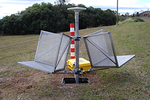
A typical geodetic monitoring station
installed as part of the Camden
Environmental Monitoring Project,
which includes two radar corner
reflectors and a mounting point for
GNSS equipment.
The Camden Environmental Monitoring Project (CEMP) is now applying the InSAR analysis technique to map movements of the Earth's surface across the Macarthur region. InSAR is a highly accurate, non-invasive remote sensing method that uses radar imagery acquired by satellites to detect changes in the height of the Earth's surface.
This project will gather and analyse new satellite radar imagery acquired every 12 days over the next three years. Scientific processing and analysis of these images will then produce 'deformation maps', which will show changes in the height of the Earth's surface over time. Interpretation of these maps will enable a clearer understanding of any potential environmental impacts, such as land subsidence, caused by resource extraction.
The project installed a network of 20 new geodetic monitoring stations throughout the study area. Each survey station includes a pair of radar corner reflectors that are visible in the satellite radar images. Regular monthly collection of GNSS data at each of the geodetic stations also provides an independent dataset of ground movements, an important validation process for the InSAR analysis.
Broader application helping more accurate positioning
Through the modernisation of the national geodetic datum, scientific models describing changes in the height of the Earth's surface over time also play an important role in ensuring the accuracy of positioning information meets the needs of all users. Applications for positioning range from the personal use of smart phones and hand-held GPS-enabled devices; through to the precise positioning capabilities required for transport systems, mining, engineering, construction and land survey activities.
Further information
Contact:
Phone:
Email:


