News
Exploring the icy waters of Casey station
Published:1 December 2014

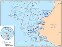
Priority areas for multibeam survey due to be
undertaken near Casey station in Antarctica
between December 2014 and February 2015
This summer, a multidisciplinary team of scientists and engineers are heading to Antarctica to uncover the secrets of the icy waters adjacent to Casey station.
Improved understanding of the seabed environment in these shallow coastal waters will ultimately lead to better environmental management within the Australian Antarctic Territory.
The waters around Casey station in East Antarctica are a high use area, frequently visited by the RSV Aurora Australis and other vessels during resupply missions and while conducting marine research in the area.
However, in areas beyond the regularly-used ship approach and anchorage, little bathymetry data is available to map and characterise the seabed environments of the area. Bathymetry data measures water depth and is equivalent to mapping topography on land.
Dr Chris Carson, a geoscientist from Geoscience Australia said the 'survey-of-discovery' will begin to fill these knowledge gaps through seafloor mapping, sampling of the seabed and assessment of the marine biodiversity.
"We hope to learn more about a number of submerged seafloor features which we think are of possible glacial origin, that were identified during a previous marine reconnaissance survey in 2013," Dr Carson explained.
This collaborative survey is being undertaken by Geoscience Australia, the Royal Australian Navy and the Australian Antarctic Division (AAD), using the AAD's 8.5 metre workboat the RV Howard Burton. The survey aims to acquire highly detailed maps of the seafloor using multibeam sonar in waters averaging less than 250 metres. The bathymetry data collection will be supplemented by physical sampling of seafloor sediments and video recordings of the biological communities living on the seafloor.
This season's survey plans to cover nearly 250 square kilometres and has been divided into nine priority areas. These priority areas were determined on the basis of scientific interest, including areas adjacent to Antarctic Specially Protected Areas and the ship tracks of the RSV Aurora Australis, which identify areas of high-use for shipping and therefore require more accurate charting.
Email:


