News
GovHack winners announced
Published:14 August 2014
GovHack winners announced

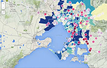
Screen grab of the Environment
Metropolitan Melbourne app which
won Best Science Hack in
GovHack 2014.
The GovHack 2014 winners have been announced, with this year's competition receiving almost 40 entries in the Best Science Hack category and 14 entries for the Best Geoscience Hack.
GovHack entries involve combining or 'mashing' data from multiple government agencies into single applications, or thinking outside the square to find ways to use government data for problem solving issues of national significance. Winning entries explored the impact of urban development on the Australian environment, and how the geology of Australia has evolved throughout the Earth's history.
"The level of interest in science and geoscience this year was excellent, and clearly indicates success for Geoscience Australia's involvement in the GovHack competition," said Dr Sue Fyfe, Director, Geoinformatics and Data Services at Geoscience Australia.
The Best Science Hack winner is Environment Metropolitan Melbourne. This app is a mash-up of data sourced from Geoscience Australia and the Melbourne City Council, to investigate possible effects of building activity on water quality. The app highlights relationships between building activity and changes in the environment that may not have been previously identified.
The Best Geoscience Hack winner is Landsat time lapse. This app is a great example of the use of Geoscience Australia's web services to visualise remote sensing data in combination with data from a range of mapping sources, in this example Bing maps are used. The app allows users to see how their suburb has changed through time, by creating an animation of Landsat satellite scenes, which are sourced from the Geoscience Australia Landsat collection hosted by the National Computational Infrastructure facility.
A runner-up prize for the Best Geoscience Hack was also awarded to Australia through time. This entry demonstrated a creative tablet application, based on the Australia Through Time poster available through the Geoscience Australia Education Centre. Geoscience Australia liked the concept so much that it is now being further developed as an iPad application.
"A key focus for Geoscience Australia is providing data via web services, so that applications like these winning entries can be quickly and easily created by software developers," Dr Fyfe added.
Geoscience Australia's participation as a Gold sponsor of GovHack in 2014, demonstrates an ongoing commitment to providing open access to government data. The GovHack event encourages software developers and web designers from government, industry, academia and the general public, to come together to explore ideas and encourages innovation using freely available government data in an effort to promote open government.
Contact:
Phone:
Email:


