News
New areas released for petroleum exploration in 2015
Published:19 May 2015
New areas released for petroleum exploration in 2015
Tom Bernecker, Tehani Kuske, Bridgette Lewis and Tegan Smith
The latest offshore petroleum exploration areas have been released by the Minister for Industry and Science, The Hon Ian Macfarlane MP at the 2015 APPEA Conference in Melbourne.
The Australian Government's annual release of offshore petroleum exploration acreage encourages investment and contributes to the responsible development of Australia's oil and gas resources. The newly released acreage covers a diverse range of geological settings. Limited data acquisition has taken place in some areas.
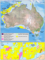
The 29 areas are located on the North West Shelf off Western Australia and the Northern Territory in the Bonaparte, Browse, Roebuck and Northern Carnarvon basins, and along Australia's southern margin in the Bight, Otway, Sorell and Gippsland basins (Figure 1). Competitive work-program bidding for exploration permits will apply, except for six selected areas that are released under the cash-bidding scheme. These are located close to existing hydrocarbon discoveries that are currently in production, where complete coverage of 3D-seismic data exists or in which proven, but to-date undeveloped, oil and gas accumulations exist.
The new acreage areas vary in water depth from very shallow (<20 metres) in the Petrel Sub-basin, offshore Northern Territory and Western Australia, through to very deep (>3 000 metres) as represented by the Bass Canyon in the eastern Gippsland Basin. The costs for drilling deep-water exploration wells has significantly increased in recent years, with shallow water areas near existing oil and gas accumulations usually attracting a higher number of bids.
Acreage release in the North West Shelf
The current offshore exploration focus in Australia is firmly on the Westralian Superbasin which includes the Bonaparte, Browse, Roebuck and Northern Carnarvon basins on the North West Shelf. The Bonaparte Basin produces natural gas from the Bayu/Undan field in the Joint Petroleum Development Area (JPDA) and from the Blacktip field in the Petrel Sub -basin. Both deliver gas via pipelines to onshore processing plants; one in Darwin and one in Wadeye. The 2015 acreage release in the Bonaparte Basin (Petrel Sub-basin) includes two cash-bid areas over the Turtle/Barnett oil and gas accumulations. These fields have been deemed sub-commercial in the past, mainly because they are hosted in reservoirs with low permeability.
The Browse Basin offers four areas this year, three of which are located in the vicinity of existing gas fields and one in the inboard area adjacent to the Cornea oil discovery. The Browse Basin is one of Australia's richest hydrocarbon provinces with an estimated 32trillion cubic feet (Tcf) of natural gas and over 350 million barrels of condensate (MMbbl) recoverable (for comparison, the total gas consumption of Australia, industrial and domestic, is around 1.2Tcf per year). Production has not yet commenced, but two large projects, the Ichthys gas development, managed by INPEX, and the floating LNG Prelude gas development, managed by Shell, are scheduled to deliver first gas in 2016.

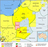
Figure 2
Map of the Roebuck Basin and
surrounding areas, highlighting the
location of 2015 acreage release
area in relation to the recent oil
discovery at Phoenix-South 1
The Roebuck Basin is a lesser-known offshore province southwest of the Browse Basin. It recently made news when the exploration well Phoenix South 1, which was intended to find additional gas in support of possible development of the original gas accumulation at Phoenix 1, unexpectedly discovered oil in September 2014 (Figure 2). Since this discovery, the Roebuck Basin has been the subject of strong interest from explorers and data acquisition companies who are keen to further assess the untapped potential of this basin. A new exploration opportunity is provided by the 2015 Acreage Release with a large block now available for work-program bidding to the north of the Phoenix wells.
The Northern Carnarvon Basin is now established as Australia's premier oil and gas province, producing 1.0-1.3Tcf of natural gas each year. The basin is well known for its vast gas resources which are converted to liquid natural gas (LNG) and exported to the Asian energy market. The basin also holds commercial volumes of oil and condensate and is therefore an attractive destination for domestic and international explorers, producers and service providers.
This hydrocarbon province always offers the largest number of new acreage blocks which this year includes seven areas for work-program bidding across the Exmouth Plateau, Rankin Platform, Dampier Sub-basin and Beagle Sub-basin. Additionally, four areas are available for cash-bidding, on trend with the inboard oil and gas accumulations of the Dampier Sub-basin, with two areas over the Chamois oil and Elk gas accumulations.
Southern margin acreage release
The overall dominance of release areas on the North West Shelf is this year counterbalanced with eight areas along the southern margin. The Bight Basin is currently undergoing a major resurgence in exploration activity and data acquisition having attracted five new players to the Ceduna-Sub-basin, which hosts the largest underexplored deltaic system in the world. According to an extensive study by Geoscience Australia in 2007, the Cretaceous sediments have the potential to generate, expel and accumulate oil which, if proven, could turn this frontier region into Australia's newest oil province. This year, a large acreage block has been added to the Ceduna Sub-basin bridging the gap to the adjacent Duntroon Sub-basin in which new data has been acquired during the last three years.

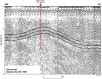
Figure 3
Seismic line G9 of 1963 vintage,
showing the large anticlinal structure
that hosts the Barracouta gas field
in the Gippsland Basin1
In the Otway Basin further east, a gas discovery was made at Speculant 1 in late 2014 confirming the prospectivity of the inboard parts of the basin. The 2015 release of four large blocks in the eastern Otway and northern Sorell basins offers the opportunity to investigate one of the many remaining offshore frontiers.
Last, but not least, two areas have been released in the Gippsland Basin. This year marks the 50th anniversary of the discovery of the giant Barracouta gas field, drilled by the then Esso Australia as Gippsland Shelf 1. The discovery, drilled on an easily identified structure (Figure 3), was the first of many more to come and by the early 1970s, the Gippsland Basin had emerged as a world class hydrocarbon province that, after 50 years, is still producing commercial volumes of oil and natural gas.
The 2015 acreage release includes two blocks in the southeastern part of the basin where the deeper, older stratigraphic section offers new exploration targets.
Further information
- Offshore Petroleum Exploration Acreage
- Geoscience Australia Acreage Release Project
- For data requests send an email to: ausgeodata@ga.gov.au
References
[1] Glenie, R.C. (ed) (1985) Second South-eastern Australia Oil Exploration Symposium, PESA Symposium, Melbourne.Contact:
Phone:
Email:


