News
New data reduces mineral exploration risk
Published:26 September 2014
New data reduces mineral exploration risk
Marina Costelloe
The largest Airborne Electromagnetic (AEM) survey by area ever undertaken in Australia will help reduce risk for mineral exploration in the Capricorn Orogen region of Western Australia.
Large regions of Australia are covered by younger sedimentary rocks that obscure the underlying older prospective basement rock layers which make direct mapping based on what appears on the surface difficult.
The Capricorn TEMPEST Survey is a $2.5 million contribution to the Distal Footprints of Giant Ore Systems project, as part of the UNCOVER Initiative. The UNCOVER Initiative led by the Australian Academy of Science is building government, university and industry partnerships to bring a competitive advantage to Australian mineral exploration. An important part of exploring under cover is the ability to use pre-competitive data, to map and characterise Australia's sediment cover and underlying mineralisation footprints.
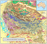
The Capricorn Orogen is a geologically complex area in Western Australia, of approximately 240,000 square kilometres or 9 per cent of the area of the state. It is prospective for potentially large discoveries of gold, copper, and other base metals. The new data will give explorers fresh insights into the region's mineral potential, reducing risk and thereby encouraging exploration investment in this frontier or 'greenfield' province.
The Capricorn 2013 AEM TEMPEST® survey covered 146 300km2, which is larger than the country of Greece. The survey was managed by Geoscience Australia on behalf of the Geological Survey of Western Australia (GSWA) as part of the Western Australia Exploration Incentive Scheme.
Airborne Electromagnetic data
Airborne Electromagnetic (AEM) data is a type of geophysical data used to map the electrical conductivity of the subsurface over extents too large to be covered by other methods on the ground. This type of data is used to generate three dimensional models of the sub-surface geology.
The AEM data are gathered by transmitting an electromagnetic signal from a transmitter system attached to a low-flying aeroplane or helicopter. A time-varying current is passed into the earth inducing electric currents to flow into conductive subsurface material. The currents are detected via the voltage that is induced in the receiver coils towed by the aircraft.

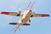
The TEMPEST® AEM airborne
electromagnetic acquisition system
used in the Capricorn Orogen airborne
electromagnetics AEM survey.
Image credit: CGG Airborne
The current flow in the subsurface geology is related to its conductivity, which is commonly caused by the presence of electrically conductive materials such as salt or saline water, graphite, clays and sulfide minerals. The AEM data acquisition method has the ability, depending on the system used, to penetrate to explorable depths less than 400 metres, but can in special circumstances provide interpretable data at depths of up to 2000 metres 1.
The use of AEM data to accurately predict conductivities from measured electromagnetic responses depends on a range of factors including received time window amplitudes, terrain clearance, aircraft attitude and estimates of changes in transmitter loop-to-receiver coil geometry. Shallow conductivity predictions (less than 150 metres) are extremely sensitive to the terrain clearance of the transmitter loop and receiver coil elements of the system, so these elements are checked using calibration and repeat line analysis.
Previous wide line spaced AEM surveys flown in Western Australia including the Paterson TEMPEST® Survey flown on behalf of Geoscience Australia in 2009 and the Bryah Basin SPECTREM® Survey flown on behalf of CSIRO and GSWA in 2012 have reinforced the value wide line spaced surveys in undercover providing coherent datasets over vast areas 2, 3.
The AEM datasets acquired during the Capricorn Orogen project will complement the now complete medium-resolution (less than or equal to 500 metre spacing) airborne magnetic and radiometric survey coverage and the reconnaissance (less than or equal to 4 kilometre stations) gravity coverage of Western Australia.
Capricorn Orogen AEM dataset
The Capricorn Orogen AEM survey is the first under the West Australian Government's Reconnaissance Airborne Electromagnetic Survey 2013-20 Program. This work program is designed to provide broad-acre, wide line-spacing, airborne electromagnetic (AEM) data over the approximately 70 per cent of the area of Western Australia that is underlain by Precambrian rocks that occur at or within about 300 metres of the surface.
In particular, the AEM dataset will determine trends in regolith conductivity and thickness; map regional variations in bedrock conductivity; and provide context for more detailed AEM surveys for mineral exploration by industry and water resources being undertaken by the Western Australian Departments of Water and Agriculture. In the Capricorn Orogen the geophysical data indicate that prospective rocks from neighbouring endowed provinces do extend underneath the barren cover.
Geoscience Australia played a key role in this project by undertaking strict quality-control and quality-assurance checks to ensure that the data were error free and ready for geological interpretation; as well as being suitable for reprocessing, enhancements and modelling to ensure the usefulness and longevity of the dataset 3.
The Capricorn 2013 AEM TEMPEST data release includes the final contractor supplied (Phase 1) datasets and report from the TEMPEST® time domain AEM survey 4, as well as a set of GSWA-produced imagery produced from the data. The AEM data collected from the surveys and resulting models, including the Logistics and Processing Report prepared by the contractor CGG 5, are now available for free download from Geoscience Australia's website.
Further information
- Unlocking Australia's hidden mineral resource potential
- Airborne Electromagnetics - Capricorn 2013 AEM TEMPEST® survey
References
[1] ^ COSTELLOE M. T. & BRODIE R. C. 2011. Kombolgie AEM survey images to 2 km. Preview February 2011, 29-32.
[2] ^ Roach, I.C., Liu, S.F., Huston, D., Costelloe, M.T., Whitaker, A.J., Czarnota, K., Williams, N., Maidment, D. & Jaireth, S., 2010. Geological and energy implications of the Paterson Province airborne electromagnetic (AEM) survey, Western Australia. Geoscience Australia Record 2010/012. Geoscience Australia, Canberra.
[3] ^ West Australian Department of Mines and Petroleum (2012) Bryah Basin SPECTREM® Survey
[4] ^ COSTELLOE M. T. & ROACH I. C. 2012. 4 AEM Geophysics. In: Roach I. C. ed. The Frome Airborne Electromagnetic Survey, South Australia: implications for energy, minerals and regional geology, pp. 125-153. Geoscience Australia Record 2012/40 DMITRE Report Book 2012/00003. Geoscience Australia/Geological Survey of South Australia, Canberra.
[5] ^ CGG 2014. TEMPEST ® Geophysical Survey Capricorn Regional Survey, Western Australia, Logistics and Processing Report 2014.
Contact:
Phone:
Email:


