News
New offshore areas released for petroleum exploration in 2017
Published:15 May 2017
New offshore areas released for petroleum exploration in 2017

The Minister for Resources and Northern Australia, Senator the Hon Matt Canavan has announced the latest offshore petroleum exploration areas at the 2017 APPEA Conference in Perth.
The Australian Government's annual release of offshore petroleum exploration acreage encourages investment and contributes to the responsible development of Australia's oil and gas resources. The newly released acreage covers a diverse range of geological settings.
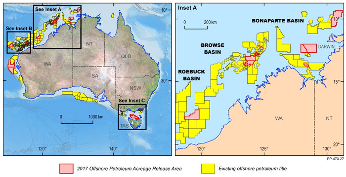
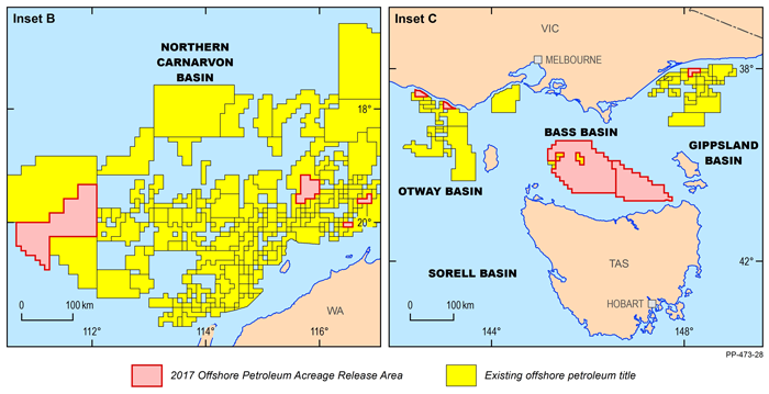
In 2017, 21 new offshore petroleum exploration areas have been released. The majority of the 2017 Release Areas are located along Australia's North West Shelf, spanning the Westralian Superbasin from the Bonaparte Basin in the northeast to the Northern Carnarvon Basin in the southwest. These are balanced by five Release Areas in the basins near Bass Strait offshore from southeast Australia, and by two offshore frontier areas in the Houtman Sub-basin of the northern Perth Basin. Following the award of one cash-bid area in the 2016 bidding round, one new area has been offered for cash-bidding in the Dampier Sub-basin.
 Overview map of the 2017 Offshore Petroleum Acreage Release, overview and inset A.
All release areas are supported by industry nominations; a process that has confirmed ongoing industry interest in obtaining prospective acreage. In order to attract robust industry participation in the bidding process, the released areas are selected to reflect geological and geographical diversity to cater for the full gamut of petroleum exploration companies.
Geoscience Australia continues to support industry exploration activities by acquiring, interpreting and integrating pre-competitive datasets that are made freely available as part of the agency's regional petroleum geological studies. A new regional 2D seismic survey was acquired in the Houtman Sub-basin of the Perth Basin, forming the basis of the latest prospectivity study carried out by Geoscience Australia. The results of the study will be presented as part of the technical program at the 2017 APPEA conference.
 Overview map of the 2017 Offshore Petroleum Acreage Release, insets B and C
A wealth of seismic and well data, submitted under the Offshore Petroleum and Greenhouse Gas Storage Act 2006 are available through the National Offshore Petroleum Information Management System (NOPIMS). Additional data sets are accessible through Geoscience Australia's petroleum data repository.
Further information:
Contact:
Phone:
Email:


