News
Piecing together Australia's past
Published:27 June 2014

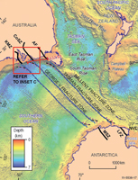
Geological map showing
fault lines between the
Australian and Antarctic
continents identified
during the tectonic
reconstruction study.
A new study by Australian and British researchers provides new understanding on how the Australian, Indian and Antarctic tectonic plates fitted together like a jigsaw puzzle 165 million years ago.
Researchers from Royal Holloway University of London, Geoscience Australia and the Australian National University used a computer program to reconstruct the western and southern margins of the supercontinent Gondwana.
The new work has revealed that previous studies had misaligned the plates, so that known geological units in Australia did not fully match with those along the opposing Antarctic rifted continental margin.
Geoscience Australia researcher Dr George Gibson said that understanding fault patterns within both the continents and in the sedimentary basins along the margins of the Australian and Antarctic continents provided the vital clues on which to better line up the various pieces. The Bight Basin along Australia's southern continental margin is currently being explored for petroleum and so it is anticipated that the results of this research will be put to immediate use by exploration companies.
"Previous studies matched a different set of ancient continental structures thereby placing Australia too far to the east with respect to Antarctica," Dr Gibson said.
"The new study proposes a different pre-breakup plate configuration in which Australia is rotated between 300 and 400 kilometres further west with respect to Antarctica, allowing for a better fit between the ancient geological units and original positions of the Australian, Antarctic and Indian plates," Dr Gibson added.
It is important that we know how the plates were configured many millions of years ago because they and their component structures have an important bearing on the pattern of continental rifting and breakup. This in turn helps us to understand how and where hydrocarbon bearing sedimentary basins formed, such as those found along Australia's southern margin.
This work is of particular importance to petroleum exploration efforts because it improves on our knowledge of the resulting fault patterns in the Bight, Otway and Sorrell basins, and how this has influenced containment and evolution of petroleum systems.
The study has been published in the internationally renowned journal Gondwana Research. A movie depicting the Gondwana margin breakup was also developed during the research.
Email:


