News
Seeing more of Australia's seafloor
Published:7 February 2019
Seeing more of Australia's seafloor
New high-resolution bathymetry datasets are now publicly available on the AusSeabed Marine Discovery Portal.
Fields of hidden volcanoes, canyons that cut through the continental shelf and oceanic plateaus that rise more than a thousand metres from the deep sea to the surface are just some of the features revealed in never-before-seen detail by new high-resolution bathymetry datasets now publicly available on the AusSeabed Marine Discovery Portal.
Head of Geoscience Australia's National Earth and Marine Observations Branch, Dr Adam Lewis said the new datasets are important because despite Australia presiding over one of the three largest exclusive economic zones on the planet, we know surprisingly little about what lies beneath the sea.
"The seafloor is really one of the last unexplored frontiers on Earth," Dr Lewis said.
"Currently, only around 20 per cent of the seafloor within the Australian Marine Jurisdiction is mapped to a level that can inform decision making.
"The more we map the seafloor, the more data we can provide to the public to support safe navigation, environmental monitoring, hazard modelling, resource management and other policy decisions."

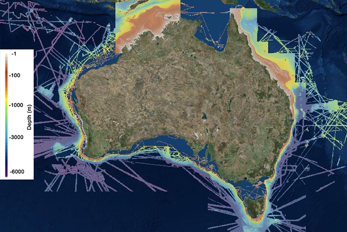
Figure 1 New high-resolution bathymetry datasets released on the AusSeabed data portal hosted by Geoscience Australia.
Dr Lewis said one of the new datasets, the 50 metre Multibeam Bathymetry, represents all the bathymetric data held by Geoscience Australia as of June 2018.

Figure 2 Features extracted from the 50 metre National Bathymetry Dataset (A-C) and the 30 metre Northern Australia Bathymetry (D). A) Volcanic seamounts adorn the continental slope in the Huon Marine Park, southeast of Tasmania. B) Details of the extensive Perth Canyon covering an area greater than 1500 km2. C) The slopes of Lord Howe Island and Balls Pyramid seamounts feature prominent ridges and rise up from the abyssal plain. D) Paleo-channels and reefs line the surface of the Browse Basin, northwest of Darwin.
"We've included data collected from more than 160 new surveys, carried out by multiple external providers around the country from 2012 to 2018 in areas that had not been previously mapped.
"The latest update to the 50 metre Multibeam Bathymetry dataset is a significant improvement. It has 34 per cent more coverage than the previous version released in 2012, and fewer artefacts-features that arise due to poor or missing data.
"We are working on tools to automate the 'processing pipeline' to improve quality assurance and reduce the manual effort involved in processing," said Dr Lewis.
Geoscience Australia Marine Geoscientist and chair of the AusSeabed Steering Committee Kim Picard said it was not just Geoscience Australia making new high-resolution bathymetry datasets publicly available on the AusSeabed Marine Discovery Portal. A collaboration between James Cook University, the Australian Hydrographic Office, the CSIRO and Geoscience Australia recently saw the addition of the 30 metre Northern Australia Bathymetry grid and 30 metre Great Barrier Reef Bathymetry grid to the portal. The CSIRO have also released their 5 metre Multibeam Bathymetry grid via the portal.
"The details of underwater features revealed by all these datasets will help scientists to explain ancient landscapes and the tectonic evolution of the Australian continent," Ms Picard said.
"They will also help to improve understanding of past sea-level change, sediment transport, underwater habitats, and geological processes."
CSIRO Facilities Program Director of the Marine National Facility, Dr Barbara Musso said the commissioning of Marine National Facility research vessel Investigator in 2014 had seen additional high quality data being collected to contribute to a whole of government approach to seafloor mapping.
"Investigator's advanced multibeam mapping capabilities are making a significant contribution to Australia's seafloor mapping" Dr Musso said.
"Along with an increased capacity to accommodate multiple projects on a single voyage, Investigator has delivered a flexible platform for dedicated and opportunistic seafloor mapping, including in priority areas where high quality data was lacking."
Ms Picard said AusSeabed, led by Geoscience Australia but operated by government, research and private sectors works to improve the awareness, coverage, quality, discoverability and accessibility of seabed mapping in the Australian region.
"Our aim by 2030 is to have total high-resolution bathymetric coverage of Australia's exclusive economic zone."
AusSeabed is hosting a seafloor mapping symposium and workshop at the Australian Marine Science Association conference in Perth from 7-11 July 2019. Abstract submissions close on Friday, 15 February 2019.
To access the new high-resolution bathymetry datasets and find out more about AusSeabed visit www.AusSeabed.gov.au.
Contact:
Phone:
Email:


