


News archive (November 2013 to July 2023)
Australia continues to rank highly for mineral exploration
3 March 2017
Australia continues to rank as the most attractive region in the world for mineral exploration investment, when both policy and mineral potential are considered, according to the 2016 Annual Survey of Mining Companies report released this week by the Canadian based Fraser Institute.
Geocentric Datum of Australia 2020 available for testing
2 March 2017
The Intergovernmental Committee on Surveying and Mapping (ISCM) has released information to aid in the uptake of the Geocentric Datum of Australia 2020 (GDA2020).
Australian Geoscience Data Cube innovation recognised on world stage
24 January 2017
The Australian Geoscience Data Cube has won the 2016 Content Platform of the Year category at the Geospatial World Leadership Awards.

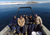
Investigating the hidden depths of East Antarctica
18 January 2017
Geoscience Australia marine geoscientist Dr Alix Post is heading to Antarctica aboard the Marine National Facility research vessel, the RV Investigator to further her work on the unique marine biodiversity of the Antarctic sea floor.
Next generation geoscientists help solve real-world problems
13 January 2017
High-performing Year 11 and 12 students from across Australia will visit Geoscience Australia throughout January, offering a unique hands-on science experience to some of Australia's best and brightest science students.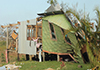
PacSAFE: Helping build a more resilient Pacific
16 December 2016
The Australian Government has announced $1 million in funding from the Pacific Regional aid budget towards the PacSAFE Project, which focuses on building disaster and climate change resilience in Samoa and Tonga.
Exploring for the Future - a new phase of resource investment in northern Australia
8 December 2016
Planning is underway on the new $100.5 million Exploring for the Future programme. This four-year programme aims to boost Australia's attractiveness as a destination for investment in resource exploration and management.
First major upgrade to the Australian Rainfall and Runoff Guidelines in 30 years
25 November 2016
The Australian Rainfall and Runoff (ARR) Guidelines have undergone their first major update in 30 years. The new guidelines provide a significant improvement in best practice flood modelling.
Results released from world-leading CO2 monitoring project
16 November 2016
Geoscience Australia and the CO2CRC Limited have released new data from three sub-surface release experiments undertaken at the Ginninderra Controlled Release Facility in Canberra, Australia.
Better prepared for bushfires and floods
14 November 2016
Natural disasters have a significant impact on Australia's economy, environment and society. They can result in loss of life, property and infrastructure, and damage our natural environment. And while we cannot prevent natural disasters, Australia can improve community resilience through effective preparation, monitoring and response.
Australia joins the world in raising tsunami awareness
4 November 2016
In the lead up to the first World Tsunami Awareness Day on Saturday, 5 November 2016, the Joint Australian Tsunami Warning Centre (JATWC) is reminding Australians what to do if a tsunami warning is issued in their area.
Building Australia's capacity to estimate the impact of terrorist blasts
31 October 2016
Building upon its existing natural hazard modelling expertise, Geoscience Australia has developed a capability which helps estimate the potential impact of terrorist blasts across a number of Australian central business districts (CBDs).Making 3D maps: 2016 GovHack winners announced
24 October 2016
This year's GovHack winners have been announced at the 2016 GovHack Red Carpet Awards held in Adelaide on Saturday 22 October. Geoscience Australia is proud to support open data through our ongoing support of the GovHack competition.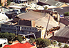
Applying science to disaster risk reduction
13 October 2016
Geoscience Australia is joining organisations from around the world today in recognising the International Day for Disaster Reduction.
Earth Science Week October 2016
5 October 2016
Earth Science Week is just around the corner. Join the celebrations from 9-15 October for a great opportunity to explore the natural world around you and celebrate the raw natural beauty of our nation's geology.
Geoscience Australia partners with Google to showcase Australia's natural history
14 September 2016
Geoscience Australia's never-before-seen collections are now available online, as part of the Google Cultural Institute's launch of more than 50 natural history collections from around the globe.
Environmental monitoring project measures surface movement using satellite data
7 September 2016
Geoscience Australia and the NSW Department of Industry's Division of Resources and Energy are using the latest satellite technology to measure potential ground movement in the Macarthur region, south of Sydney
Exploring the marine secrets of Northern Territory's Bynoe Harbour
26 August 2016
A team of marine scientists have completed a marine mapping survey of the sea floor of Bynoe Harbour in the Northern Territory, building on the existing knowledge and understanding of this unique seabed habitat.

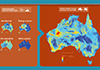
Updated gravity datasets deliver a treasure map for mineral and energy exploration
22 August 2016
Australia now has a full suite of new gravity grids at the national scale, being the first publically released since 2011.
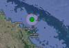
Magnitude 5.8 earthquake shakes far north Queensland
Some of far north Queensland's most popular tourist destinations have been shaken by a large magnitude 5.8 earthquake, followed by a series of smaller aftershocks.
Opportunity to explore the wonders of geoscience
15 August 2016
Canberrans can learn about the science behind Pokémon GO - and catch a few as well - this coming Sunday at Geoscience Australia's 2016 Open Day.
Contributing science expertise to meet global challenges
4 August 2016
Sustainable development of human society depends on economic, social and environmental challenges being addressed globally. Geoscience Australia has a crucial role to play in this, through expertise in geospatial information management.
Join a behind the scenes tour of Geoscience Australia
2 August 2016
Geoscience Australia will be offering three exclusive behind-the-scenes tours of its building and collections during National Science Week.
Continental-scale mapping of mineral potential wins top award
28 July 2016
A Geoscience Australia project that is helping to build a better understanding of Australia's mineral potential has won the Engaging with the Edge category of the 2016 Public Sector Innovation Awards.
Save the date for Geoscience Australia's 2016 Open Day
29 July 2016
The count-down is on to Geoscience Australia's annual Open Day on Sunday 21 August, when we invite the community along to learn about the exciting and diverse range of work carried out by Australia's national geoscience organisation.

Interim Australian Energy Resource Assessment Report now available online
1 August 2016
Geoscience Australia has released the interim 2016 Australian Energy Resource Assessment (AERA) report, providing the latest update in the series of national assessments of Australia's energy resources.
Team effort to establish world-class AuScope GNSS network
8 July 2016
The collaborative effort led by Geoscience Australia to establish the AuScope Global Navigation Satellite System (GNSS) network, is making Position, Navigation and Timing satellite data more accessible to the Australian and international geospatial community.
Important upgrade to Geoscience Australia's magnetometer calibration facility
4 July 2016
Why is there life on Earth? We owe this phenomenon greatly to the Earth's magnetic field. This invisible force protects the planet from harmful cosmic radiation and charged particles that radiate from the sun in the form of solar winds and geomagnetic storms.
New Bushfire Toolbox supports better building design
6 June 2016
Fire is a natural feature of the Australian landscape and remains an ever-present threat. Understanding the risk and potential impacts of bushfire can help communities make better decisions to prepare for, and mitigate against, these risks.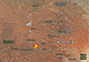
Largest earthquake in nearly 20 years shakes Central Australia
23 May 2016
Australia experienced its largest earthquake in nearly 20 years on Saturday morning when a magnitude 6.1 hit the red centre, waking up tourists and locals alike.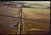
Shaking up Australia's earthquake sizes
11 May 2016
As a result of a global project to more accurately measure historical earthquakes, Australia's list of largest recorded earthquakes has dramatically changed.

Exploring for the Future
4 May 2016
The Australian Government's 2016-17 Budget brings a boost for Geoscience Australia through funding of a new programme Exploring for the Future.

The Budget 2016-17
3 May 2016
Geoscience Australia's budget information is published in the Industry, Innovation and Science Portfolio Budget Statements.
Geoscience Australia welcomes new Antarctic icebreaker
2 May 2016
Geoscience Australia welcomes the Government's investment in a new world-leading Antarctic icebreaker for Australia.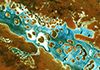
Establishment of a satellite data hub to benefit Australia and international partners
5 April 2016
Australia will have assured access to reliable and operational satellite data from the European Union's Sentinel satellites under the terms of a technical cooperation arrangement signed between the European Space Agency (ESA) and Geoscience Australia on 30 March 2016.
Celebrating 70 years of trusted geological advice
18 March 2016
Geoscience Australia is celebrating 70 years as the nation's trusted geological advisor, marking the decision to establish the Bureau of Mineral Resources, Geology and Geophysics (BMR) on 20 March 1946.
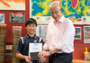
Milestone visit for Geoscience Australia's Education Centre
19 February 2016
Geoscience Australia's Education Centre celebrated a significant milestone this week by welcoming a very special student visitor through its doors.

Student scientists unlock the secrets of the Earth
28 January 2016
Students from across Australia have been welcomed to Geoscience Australia in January, as part of the annual National Youth Science Forum (NYSF).
Secrets of Darwin Harbour - from sand waves to shipwrecks
1 December 2015
Darwin is world renowned for its rich and diverse landscapes, but as a scientific exploration party has just discovered, there is an equally diverse and until now undiscovered region of Darwin under the sea.
Australia and the European Union enter historic arrangement on Earth observation
5 November 2015
Australia's access to vital satellite data has been assured through the signing of a cooperation arrangement in Brussels today between the Australian Government and the European Commission.
Celebrate Earth Science Week with our interactive quiz - and more!
12 October 2015
To celebrate Earth Science Week 2015, our geoscience experts have prepared a range of fun and challenging activities to highlight many aspects of how our planet works and put your geoscience knowledge to the test.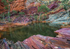
'Hamersley Gorge' is Australia's 2015 Top GeoShot
14 October 2015
Craig Burns from the Australian Capital Territory has taken out Geoscience Australia's 2015 Top Geoshot photo competition, with his photo of Hamersley Gorge in Western Australia.
Join the Earth Science Week 2015 celebrations
23 September 2015
The countdown is on to Earth Science Week 2015, with annual celebrations due to kick-off in October - or 'Rocktober' as we prefer to call it!
New visitor experiences showcase the minerals of Broken Hill
18 September 2015
A new exhibition and behind-the-scenes tours at Geoscience Australia celebrate the rich mining history of the Broken Hill region, and highlight some of the now rare mineral samples held within Geoscience Australia's mineral collection.
2015 GovHack winners announced
7 September 2015
Geoscience Australia is proud to support the principle of open data by sponsoring GovHack 2015, which saw teams from across Australia and New Zealand compete to develop new applications using open Government data.
Opportunity to explore the wonders of geoscience
18 August 2015
The opportunity to mix with Australia's top geoscientists, learn how a dancing robot helps your GPS, or find out how earthquakes are detected will be on offer this coming weekend at Geoscience Australia's 2015 Open Day.
New vision for Australian marine science
12 August 2015
Geoscience Australia welcomes the release of the National Marine Science Plan launched by Minister for Science Ian Macfarlane at Parliament House in Canberra on 11 August 2015.
Upgraded bushfire monitoring capability to keep communities safer
11 August 2015
A new and improved bushfire monitoring system will be in place for the 2016 disaster season, transforming an existing delayed monitoring service into a more responsive emergency management tool for firefighters.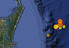
String of large earthquakes shakes Queensland's east coast
For the second time in a matter of days residents along some of Queensland's most popular tourist destinations have been shaken by earthquakes.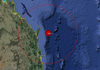
Queensland's Sunshine Coast feels largest earthquake in nearly a century
30 July 2015
Residents on the Queensland east coast started their day in unusual circumstances this morning when an offshore earthquake shook areas from the south Gold Coast all the way to Gladstone.