


News archive (November 2013 to July 2023)

New dataset provides clues to potential mineralisation
10 July 2014
Geoscience Australia has released new map data which will aid the search for new mineral deposits and improve our understanding of the geological evolution of the Australian continent.
Australia's big challenges - the role of geoscience
8 July 2014
This Insights article is an overview of the keynote presentation by Geoscience Australia’s Chief Executive Officer Dr Pigram at the 2014 Australian Earth Sciences Convention.
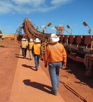
UNCOVER: unlocking Australia's hidden mineral potential
7 July 2014
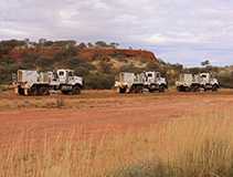
New and innovative products and techniques are being developed as part of the UNCOVER Initiative to help attract mineral exploration investment that has the potential to lead to the discovery of new resources.

Water from rocks in Timor-Leste
4 July 2014
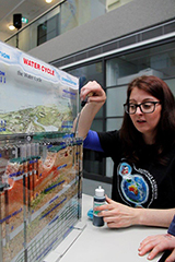
Water availability can often be limited in many districts of Timor-Leste, particularly during the dry season that often lasts for over half the year.
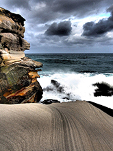
Life in icy waters: using geoscience information to protect life on the Antarctic seafloor
30 June 2014
Work by marine geoscientists from Geoscience Australia is helping to improve understanding of the unique communities of organisms that live on the Antarctic seafloor.
Marine geoscience takes centre stage
26 June 2014
A marine coastal setting seems like the most likely location for the annual conference of the Australian Marine Sciences Association - however this year it is being held in Canberra.

GovHack: promoting open access to our data
3 June 2014
As part of our commitment to providing open access government data, Geoscience Australia is hosting a DataJam session in the lead-up to GovHack.
Dynamic topography of Australia's margins
30 May 2014
It is well known in the geosciences that most of the Earth's topography and bathymetry is a consequence of tectonic plates thinning or thickening along their boundaries.
Towards an understanding of social vulnerability and resilience to disasters
29 May 2014
Science can tell us much about the nature of floods, how fires behave and the response of a building to strong winds. However, not as much is known about how a person will behave or react in the face of unfolding disaster.
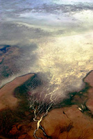
Spaceship Earth exhibition opens in Sydney
22 May 2014
The iconic Spaceship Earth philosophy that reversed our inward view of our planet has now inspired a new satellite imagery exhibition that opens in Sydney this week.
Antarctic minerals new to science
20 May 2014
Some very special Antarctic rocks, containing rare minerals which have never been found anywhere else on Earth, will now be protected under international treaty.
The Budget 2014-15
13 May 2014
Read about the outcomes for Geoscience Australia in the Budget 2014-15. Our Agency's budget report is incorporated in the Department of Industry Portfolio Budget Statement 2014-15.
South Australian town tops annual list of Australian earthquakes two years in a row
7 May 2014
The small town of Ernabella (Pukatja) in South Australia has recorded the largest earthquake in the nation for two consecutive years, experiencing a 5.7 magnitude event in both 2012 and 2013.
Exploring Antarctica's marine biodiversity hotspots
24 April 2014
Over the past summer, a team of scientists from the United States and Australia travelled to Antarctica to discover the secrets of the unexplored regions near the Totten Glacier in Australia's Antarctic Territory.
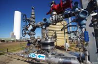
Understanding Northern Australia's Carbon Capture and Storage Potential: An Integrated Regional CO2 storage study
24 April 2014
The completion of a recent study by Geoscience Australia indicates that the Petrel Sub-basin (Bonaparte Basin), offshore Northern Territory, is suitable for the geological storage of CO2.
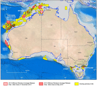
2014 Offshore Petroleum Acreage Release announced
9 April 2014
The Minister for Industry Ian Macfarlane has formally released the latest offshore petroleum exploration areas at the annual Australian Petroleum Production and Exploration Association conference being held in Perth this week.
Overview of the 2014 offshore acreage release areas for petroleum exploration
9 April 2014
The latest offshore petroleum exploration areas have been formally released by the Minister for Industry Ian Macfarlane at the 2014 annual Australian Petroleum Production and Exploration Association (APPEA) conference.
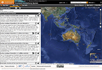
New disaster management software released worldwide
8 April 2014
Geoscience Australia has contributed to a new version of software that can predict the potential social and human impact of natural disasters.
New geophysical data for CO2 storage and hydrocarbon prospectivity in the Browse Basin
3 April 2014
Government-funded pre-competitive regional-scale airborne magnetic data have an important role to play in helping to understand energy and mineral systems.
Marine treasures of Tasmania's Flinders Island
20 June 2014
Marine geoscientists have gained an amazing underwater view of the Flinders Commonwealth Marine Reserve, located off northeast Tasmania.
Release of updated Australian Energy Resource Assessment
13 June 2014
Geoscience Australia and Bureau of Resources and Energy Economics have released an update of the Australian Energy Resource Assessment.
Supporting Australia's search for oil and gas
28 May 2013
Old rocks prove their exploration potential
29 May 2013
Open Day explores the wonders of geoscience
12 August 2013
Geoscience Australia welcomes virtual visitors
12 August 2013

Four weeks left to become Australia's next Top GeoShot
26 August 2013
2013 Top GeoShot winners announced
17 October 2013
New phase for Chinese-Australian CO2 storage collaboration
8 May 2013
Australia and China can expect to have an improved understanding about the geological storage of carbon dioxide (CO2) following a meeting in Melbourne this week of leading researchers from both countries.
Access to products and data made easy
8 May 2013
To help you access Geoscience Australia's diverse range of data, products and services we have created a new purpose built interface, with text and map search functions.
Do you have Australia's next Top GeoShot?
11 May 2013
Entries are now open for Geoscience Australia's 2013 Top GeoShot photographic competition.

Budget 2013-14 - What this means for Geoscience Australia
14 May 2013
The 2013-14 Budget was delivered by The Treasurer, the Hon Wayne Swan MP this evening.

Sub-millimetre accuracy for global positioning
21 May 2013
A new antenna calibration facility installed at Geoscience Australia will significantly improve the accuracy of satellite positioning technologies that underpin a range of industrial and research applications.
Helping developing countries manage their own resources
23 May 2013
The Minister for Resources and Energy Gary Gray today released a new report that will provide guidance on how Australia can give a helping hand to developing nations to manage their own mineral and energy resources.
2013 Acreage Release provides opportunities in underexplored regions
28 May 2013
The Minister for Resources and Energy Gary Gray has released new offshore petroleum exploration areas at the annual Australian Petroleum Production and Exploration Association (APPEA) conference in Brisbane.
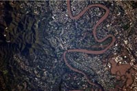
Flood reconstruction takes many forms
19 June 2013
A recent survey in parts of Brisbane and Ipswich has revealed that extensive reconstruction and redevelopment has taken place in the wake of the devastating floods which hit the two centres in 2011.
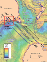
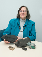
Piecing together Australia's past
5 July 2013
A new study by Australian and British researchers provides new understanding on how the Australian, Indian and Antarctic tectonic plates fitted together like a jigsaw puzzle 165 million years ago.
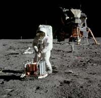
Seismic recording marks first Moon walk
9 July 2013
When Neil Armstrong and Edwin 'Buzz' Aldrin were enjoying the special experience of being the first humans to wander on the surface of the Moon in July 1969, they were also creating something unique - the first lunar seismic event registered on Earth.
New report highlights Australia's potential to help meet global demand for critical commodities
17 July 2013
Australia has the potential to play a major role in meeting global demand for commodities used in the production of high-tech devices such as smart phones and flat screen televisions, as well as renewable energy and low-emissions technologies like wind power and electric cars, according to a report released today by the Minister for Resources and Energy Gary Gray.
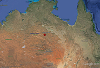
Tennant Creek shakes again
19 July 2013
Tennant Creek residents were sent to bed last night with a shake as a magnitude 4.2 earthquake hit approximately 30 kilometres southwest of the township.
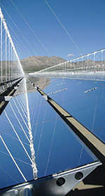
New Portal highlights Australia's prime solar locations
29 July 2013
Companies looking to invest in large-scale solar power plants can now locate Australia's prime solar resource development areas via a new online Portal announced by the Minister for Resources and Energy Gary Gray.
New supercomputer sheds light on historical geographic data
31 July 2013
Australia's highest performance supercomputer was officially booted up at today's opening of the National Computational Infrastructure high performance computing centre at the Australian National University.

New movie explains the importance of remote sensing
2 August 2013
Geoscience Australia has produced a short movie highlighting the importance of remote sensing to the geosciences and to society.
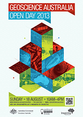
Come explore the wonders of geoscience
2 August 2013
Come and explore the wonders of geoscience when Geoscience Australia hosts its annual Open Day on Sunday 18 August.
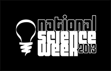
Geoscience Australia reaches out in National Science Week
5 August 2013
There will be more to Geoscience Australia's National Science Week activities than just our Open Day, with several public lectures by our scientists taking place across Canberra.
Critical commodities for a high-tech world report re-issued
14 August 2013
The report on Critical commodities for a high-tech world: Australia's potential to supply global demand has been re-issued and includes corrected data on mineral resources and production.
Australia's foundations revealed in a new atlas
11 September 2013
Resource explorers, mining companies, researchers and the public will have improved opportunities to more closely investigate what geological structures lie beneath Australia with the release of an atlas of Australia's deep seismic reflection profiles.
New records set for Geoscience Australia's Open Day
20 August 2013
Geoscience Australia's Open Day, held on Sunday 18 August, was another great success with a new record of around 8000 happy and interested visitors through the door.
Earth Science Week 2013 - Mapping our World
17 September 2013
The count-down is on to Earth Science Week 2013, with annual celebrations due to kick-off in a few weeks. Find out how you can 'rock' October and map your world.
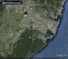
Earthquake recorded near Campbelltown
8 October 2013
Residents of Sydney's outer suburbs started their day with a shake this morning as a magnitude 3.5 earthquake hit the Campbelltown region at 7:15am.
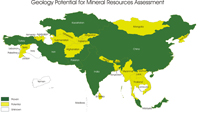
Australia's Mineral Resource Assessment
1 November 2013
Potential investors have the opportunity to evaluate Australia's mineral resource industry potential with the aid of a newly released assessment of the country's minerals industry.