Case study Assessing and improving Western Australia’s vulnerability to tropical cyclones
How scenario modelling helped emergency managers in Western Australia to mitigate the impacts of tropical cyclone hazards.
Page last updated:21 August 2021
The problem
Knowing the tropical cyclone risk
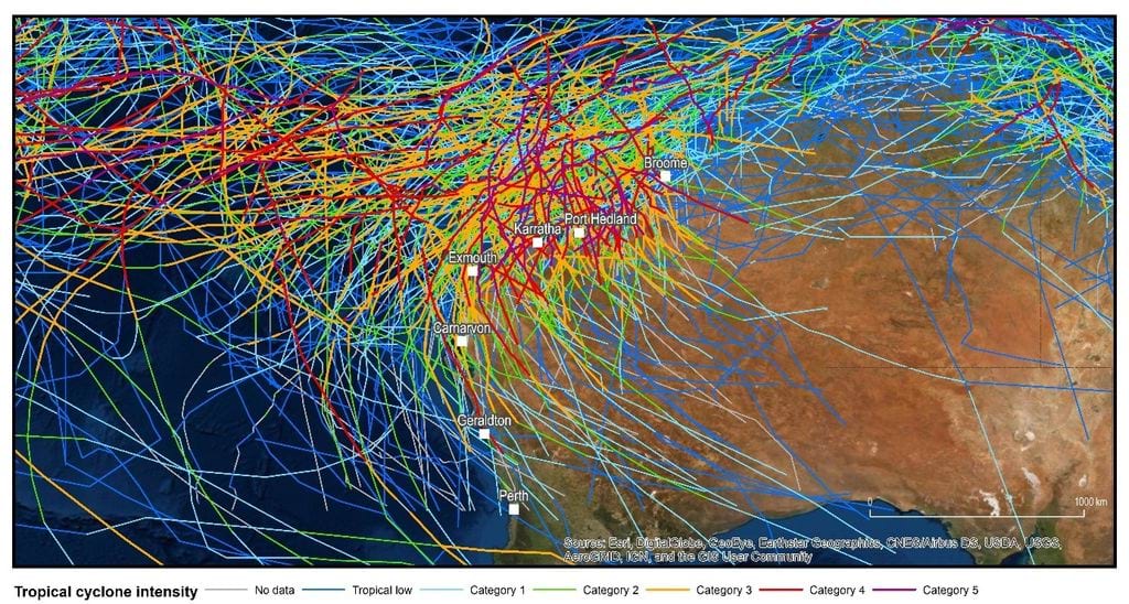
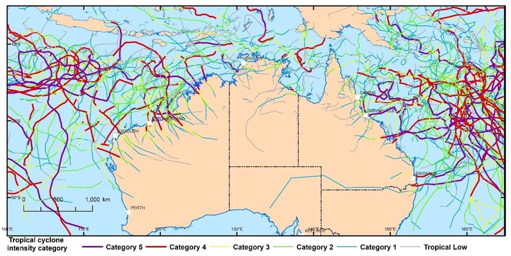
The north-west Australian coastline from Broome to Exmouth has experienced the greatest number of tropical cyclones making landfall in Australia since records began in 1908. As the coastline is sparsely populated, direct impacts of a tropical cyclone on individual communities are unusual, as they’re generally spaced hundreds of kilometres apart and a tropical cyclone can cross the coast between them with little impact.
But there is real potential for extreme events to strike in and around these communities and cause severe damage. The highest recorded wind gust in the world was 408 km/h (Category 5) at Barrow Island off the coast of Western Australia (WA) during tropical cyclone Olivia on 10 April 1996. The highest recorded wind gust on the Australian mainland was 267 km/h (Category 4) at Learmonth during tropical cyclone Vance on 22 March 1999.
Little is known about the direct impact caused by tropical cyclones on townships along the northern WA coastline, due to a lack of data and historical analogues. The risk to the area remains high and the potential impact uncertain.
The solution
Working with the WA Department of Fire and Emergency Services (DFES) to gain a better appreciation of severe wind risk, we:
- undertook a four-year Severe Wind Hazard Assessment (SWHA) project, supported by the Natural Disaster Resilience Program
- modelled a number of event scenarios using nationally consistent data and information
- applied the ‘hazard, exposure and vulnerability’ framework to assess the impact from these scenarios, exploring hazard (intensity and likelihood), exposed assets (people, buildings, roads, economy, agricultural assets, infrastructure, etc.) and vulnerability (the level of damage for the intensity of the hazard).
Historical tropical cyclones in the Western Australian region 1907–2017. Tracks are coloured by the estimated intensity category, based on minimum central pressure. Source: Bureau of Meteorology/IBTrACS.
Geoscience Australia works with state and local governments and the emergency management industry sector across Australia to develop local hazard assessments. For more information, contact hazards@ga.gov.au
How we got there
Tropical cyclone scenario modelling
Geoscience Australia developed a range of scenarios using the Tropical Cyclone Risk Model (TCRM) for locations selected in consultation with DFES and the Bureau of Meteorology (WA Regional Office).
Seven communities were chosen, with 2 tropical cyclone events modelled for each location (one Category 3 event, reflecting historical experience and likelihood, and one Category 5 as a ‘worst-case’ scenario):
- Broome
- Port Hedland
- Karratha and Roebourne
- Exmouth
- Carnarvon
- Geraldton
- Perth
Using our Hazard Impact Assessment application (HazImp), we determined the magnitude of structural damage to buildings based on location-specific wind speed by combining:
- Wind speeds from the tropical cyclone scenario events modelled by the Tropical Cyclone Hazard Assessment (TCHA)
- The influence of topography and vegetation extracted from our Local Wind Multipliers dataset, and
- Appropriate vulnerability models based on the location, building use and construction attributes extracted from our National Exposure Information System (NEXIS)
The scenario analysis found that building age and corresponding structural vulnerability were key drivers in the likelihood of damage. Residential houses built before modern building codes were introduced (pre-1980s) in older suburbs along the coastline were likely to suffer significant damage. In a real event, there would be considerable implications for emergency management in these suburbs, as large numbers of people would need to be evacuated and provided with temporary accommodation, and significant reconstruction efforts would be required.
Reducing the vulnerability of buildings is a collective community effort. The project was able to highlight areas with a high proportion of older residential buildings and identify them for increased homeowner maintenance and retrofitting to modern building standards.
Providing tangible information and knowledge on Western Australian regions allowed community members to fully appreciate the impacts of probable cyclone events, and to identify the need to quantify the benefits (reduction of risks) of a range of mitigation options.
How this helps improve community safety in Western Australia
The assessment provided the Western Australian Government and the Department of Fire and Emergency Services with evidence to plan for and reduce the impact of tropical cyclone hazards before the next event.
The analysis gave emergency managers from local, district and state levels a wealth of information on the potential scale of impact that a major cyclone could have on WA communities. It created opportunities to strengthen planning processes and raised community awareness of mitigation actions that could reduce impacts – such as pre-cyclone-season initiatives encouraging the collection of debris that could become potential missiles during a cyclone.
The DFES collaboration with Geoscience Australia in Western Australia saw the state better prepared than ever before for upcoming tropical cyclone seasons.
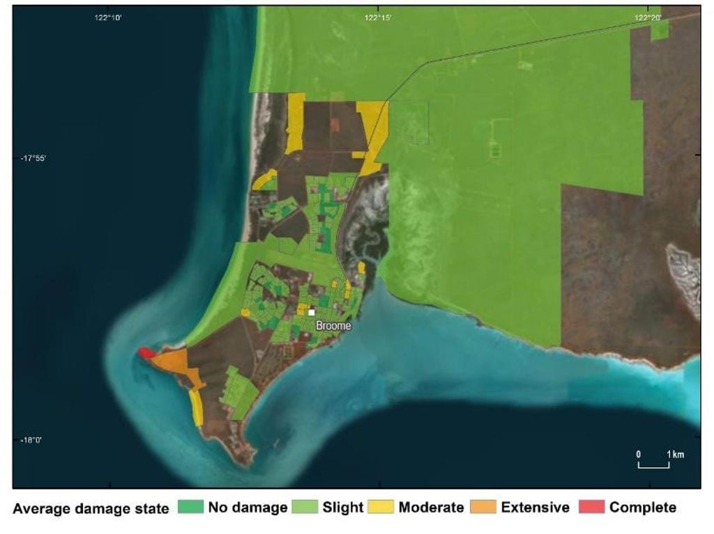
Aggregated residential building damage states for mesh block areas, for scenario 012-06287, a Category 3 cyclone impacting Broome, WA
Looking forward
Supporting evidence-based decisions for government, industry and the emergency services
- DFES and the Western Australian Government are using the insights from this project to make evidence-based decisions on severe wind and tropical cyclone hazards, now and into the future.
- The scenario impact models developed for Karratha and Port Hedland were used to inform resource allocation decisions ahead of tropical cyclone Veronica making landfall in March 2019 and tropical cyclone Damien doing the same in February 2020. DFES was able to use the already modelled Category 3 and Category 5 scenarios as a guide to understanding how these events could unfold and where vulnerable parts of the communities were located.
- Geoscience Australia trialled the Tropical Cyclone Impact Modelling (TCIM) automated impact modelling service during Tropical Cyclone Seroja, which made landfall between Kalbarri and Port Gregory on 11 April 2021. Having access to this data was a considerable support for the agencies involved in managing the cyclone hazard.
- Geoscience Australia is continuing to collaborate with international and Australian science organisations to undertake long-term research that supports reducing risk to natural hazards.
- Our science, data and tools reflect the latest advancements in science, technology and best practice. We’re working towards the inclusion of a multi-hazard assessment so we can ensure Australian communities are as safe as possible from the consequences of natural hazard events.
How we can help you
Contact us to gain a better understanding of the cyclone and severe wind risk in your state, region or sector so you can develop targeted and effective risk mitigation and risk reduction strategies.
Our cyclone and severe wind resources can help identify your region’s high-threat areas so you can make better-informed natural hazard decisions.
Email hazards@ga.gov.au
