Data product Probabilistic Tsunami Hazard Assessment (PTHA) Guidelines
Assess earthquake-tsunami inundation hazards with a focus on the Pacific.
Page last updated:18 June 2024
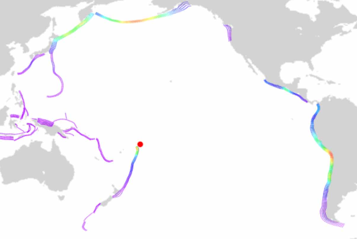
A global map with probabilistic tsunami scenarios superimposed with varying colour to indicated intensities.
Assessing the onshore tsunami inundation risk
The Pacific Ocean experiences more tsunami than any other body of water in the world, with most generated by undersea earthquakes. Tsunami are generally most destructive when they inundate the land, so tsunami inundation assessments are designed to estimate how deep the water may get, and how often this might be expected to occur.
The PTHA Guidelines present two methods to assess the tsunami inundation risk for Pacific island nations using Geoscience Australia’s Probabilistic Tsunami Hazard Assessment (PTHA18) – a global database of modelled earthquake–tsunami scenarios. PTHA18 is used to model the likely frequency of tsunami caused by undersea earthquakes, and can be used to assess the onshore inundation hazard risk in the Pacific by combining the modelled earthquake–tsunami scenarios with user-provided tsunami inundation models.
Who are the PTHA Guidelines for?
The PTHA Guidelines are designed to support Pacific Island countries in using PTHA18 to produce tsunami inundation hazard information. The Guidelines are used by scientists, academic institutions and technical specialists, to help Pacific Island governments to understand and mitigate their region’s tsunami risk.
How the PTHA Guidelines work
- The Guidelines explain how to produce tsunami inundation hazard information using the PTHA18 database.
- PTHA18 considers the natural variability of earthquake size and slip, which affects the height and hazard of predicted tsunami waves. It includes modelled data on the frequency of a given wave height, and the uncertainties in these frequencies.
- Modelling from the PTHA18 can be combined with tsunami inundation models to assess the onshore inundation hazard risk for Pacific Island nations, including the chance of inundation over a specified time period, and water depth estimates.
- The PTHA Guidelines present two methods to assess the tsunami inundation hazard for a given location:
- Monte-Carlo sampling: simulation of many tsunami scenarios in a way that allows for rigorous translation of the offshore PTHA18 to a specific onshore site. It enables uncertainties in the offshore PTHA to be fully represented onshore, but is computationally demanding.
- Scenario-based: simulation of a limited number of tsunami scenarios which are inferred from offshore PTHA results. This approach is less computationally demanding than Monte-Carlo sampling and is very flexible, but doesn’t provide probabilistic onshore results.
- Access the PTHA guidelines
Good to know
The PTHA18 and the PTHA Guidelines only consider tsunami generated by undersea earthquakes. Other non-earthquake sources that can cause a tsunami, such as landslides, volcanic activity or meteorological events are not included. Separate research is being conducted by the scientific community to establish a consistent treatment for these other tsunami sources.
Looking forward
Our research into tsunami hazard assessment methodologies, including offshore-to-onshore PTHA, will continue into the future, allowing the PTHA Guidelines to evolve as technology advances and scientific knowledge increases. Ensuring the Guidelines reflect these advancements will help keep communities as safe as possible from tsunami events. At Geoscience Australia, we’ll also continue to encourage the open licensing of datasets and support collective efforts towards community safety in the region.
Project Mapping and modelling the impact of earthquake-generated tsunamis on the coastal communities of Western Australia
How Geoscience Australia is creating evidence-based inundation maps to guide emergency management planning for earthquake-generated tsunamis.
Related products
Tropical Cyclone Risk Model Software (TCRM)
Estimate average recurrence interval wind speeds and potential tropical cyclone wind hazard.
Tropical Cyclone Scenario Selector Tool
Use this interactive tool for querying, visualising and downloading cyclone scenarios plausible future tropical cyclone scenarios used for risk management and planning.
Wind multipliers
Learn more about our significant research on wind speed undertaken due to its importance in predicting, mitigating and managing major risks and hazards caused by wind.

National Exposure Information System
Use our nationally consistent exposure data to help understand what could be at threat from natural hazards.