Project Understanding the potential impacts of an earthquake in the Hobart area
Modelling earthquake scenarios in Hobart to improve earthquake resilience across Tasmania.
Page last updated:18 June 2024
The problem
Assessing the impact of an earthquake event in the Hobart area
Although Australia is a relatively stable continent, earthquakes do occur. The most devastating earthquake occurred in 1989 in Newcastle, New South Wales, where 13 people died and more than 160 people were injured. Tasmania is also vulnerable to earthquakes, and in the past century, several significant earthquake events have been recorded. In 1929, an earthquake off the north-east coast of Tasmania damaged buildings and property in Launceston.
The Tasmanian State Natural Disaster Risk Assessment (TSNDRA) 2016 identifies that a future earthquake has the potential to cause significant damage to buildings and infrastructure in Tasmania. Many unreinforced brick and stone (masonry) buildings would be at risk of collapse, and the state’s electricity supply could also be affected. If a large earthquake were to occur at Lake Edgar Fault, 80 kilometres west of Hobart, the dams of the Gordon River Hydro-Electric Power scheme could fail, with devastating impacts on the local environment and a substantial proportion of the state’s population.
The consequences of an earthquake event, along with the best strategies to mitigate this risk in Tasmania, are not well understood and priorities for risk reduction are unclear. While Tasmania does have some information on buildings, there is no complete inventory of all building types with vulnerable buildings identified. Modelling the impacts of a potential earthquake in the Hobart area and earthquake risk across the state will allow stakeholders to develop appropriate emergency planning and mitigation strategies to address the risks.
What we’re doing
Using data and scenario modelling to create an evidence-based understanding of earthquake risk
From July 2021 to June 2022, Geoscience Australia is working with the Tasmanian Department of State Growth and Mineral Resources Tasmania (MRT) to develop a detailed understanding of the potential impacts of earthquake events in the Hobart area. Through the Earthquake Risk and Mitigation Assessment in Tasmania project, we are:
- Refining the mapping of where soil conditions beneath Tasmanian communities could amplify earthquake impacts by integrating detailed local geological mapping and geotechnical information supplied by MRT
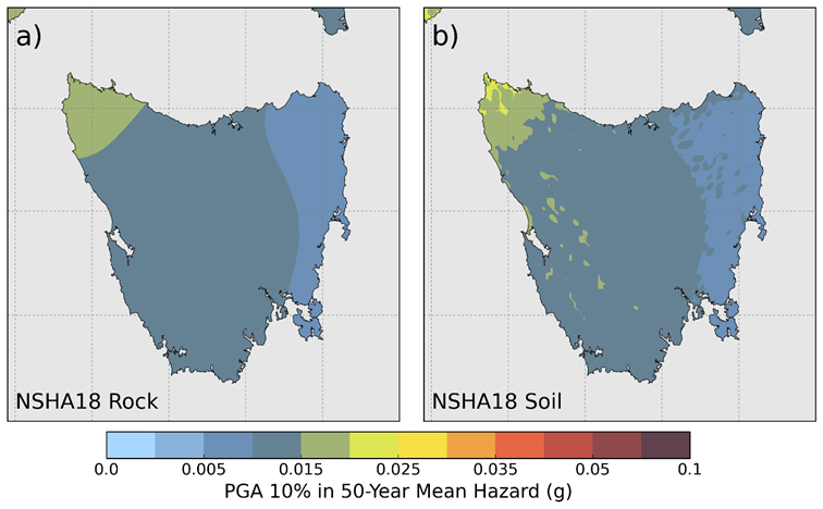
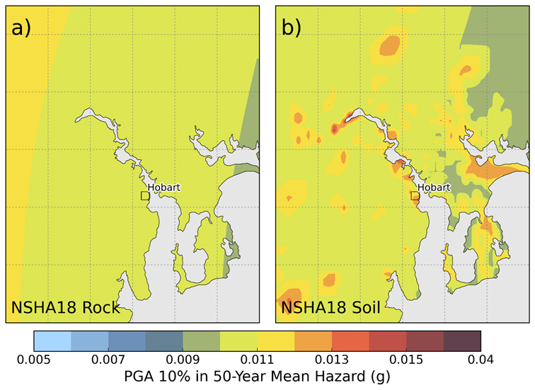
- Assessing the surface earthquake hazard using Geoscience Australia’s National Seismic Hazard Assessment (NSHA), the Australian Seismic Site Conditions Map (ASSCM) and the refined soil mapping from this project.
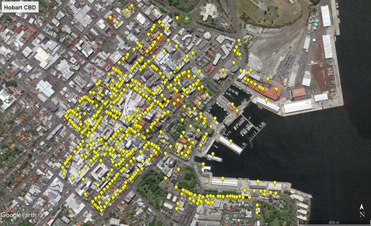
- creating an improved inventory of Hobart buildings and demographic data by merging information from the National Exposure Information System with Geoscience Australia’s engineering survey of the Hobart CBD and a desktop survey of hospitals, schools and emergency management facilities identified by MRT.
- Mapping earthquake vulnerability to the Tasmanian building stock with a particular focus on high-risk unreinforced masonry buildings in the Hobart CBD having cultural heritage value and other key Hobart buildings of post-earthquake utility such as schools, hospitals and emergency services facilities.
- Modelling the potential impacts of three earthquake scenarios – one along the Lake Edgar Fault Rupture and another closer to Hobart – to estimate the likely damage to buildings and infrastructure, and potential deaths and injuries.
- Drawing upon vulnerable masonry building retrofit research undertaken collaboratively by Geoscience Australia as part of the Earthquake Mitigation of WA Regional Towns York project, conducted with the Bushfire and Natural Hazards CRC and the WA Natural Disaster Resilience Program
- Providing strategies to retrofit unreinforced masonry buildings and reduce the risk of collapse, especially in high-risk areas with significant pedestrian traffic.
Geoscience Australia works with state and local governments and the emergency management industry sector across Australia to develop local hazard assessments. For more information, contact hazards@ga.gov.au
Looking forward
Drawing on local and national disaster resilience expertise to benefit all of Tasmania
- The Earthquake Risk and Mitigation Assessment in Tasmania project is strengthening collaboration between Geoscience Australia’s earthquake researchers and the Tasmanian Department of State Growth’s risk management team.
- The data collected is being used to educate Tasmanian planners, infrastructure owners and construction specialists about the potential impacts of an earthquake on the state’s built environment and implement practical solutions to improve resilience.
- The project’s research findings will be shared with emergency services, local governments and stakeholders across Tasmanian communities to improve the state-wide understanding of community exposure, vulnerability, earthquake risk, disaster planning needs and mitigation strategies.
How you can strengthen your earthquake resilience with Geoscience Australia
Use our resources to gain a better understanding of the earthquake risk in your state, region or sector, so you can develop targeted and effective risk mitigation and risk reduction strategies.
Our earthquake resources can help identify your region’s high-risk areas so you can make better-informed natural hazard decisions.
Email hazards@ga.gov.au
Related Information
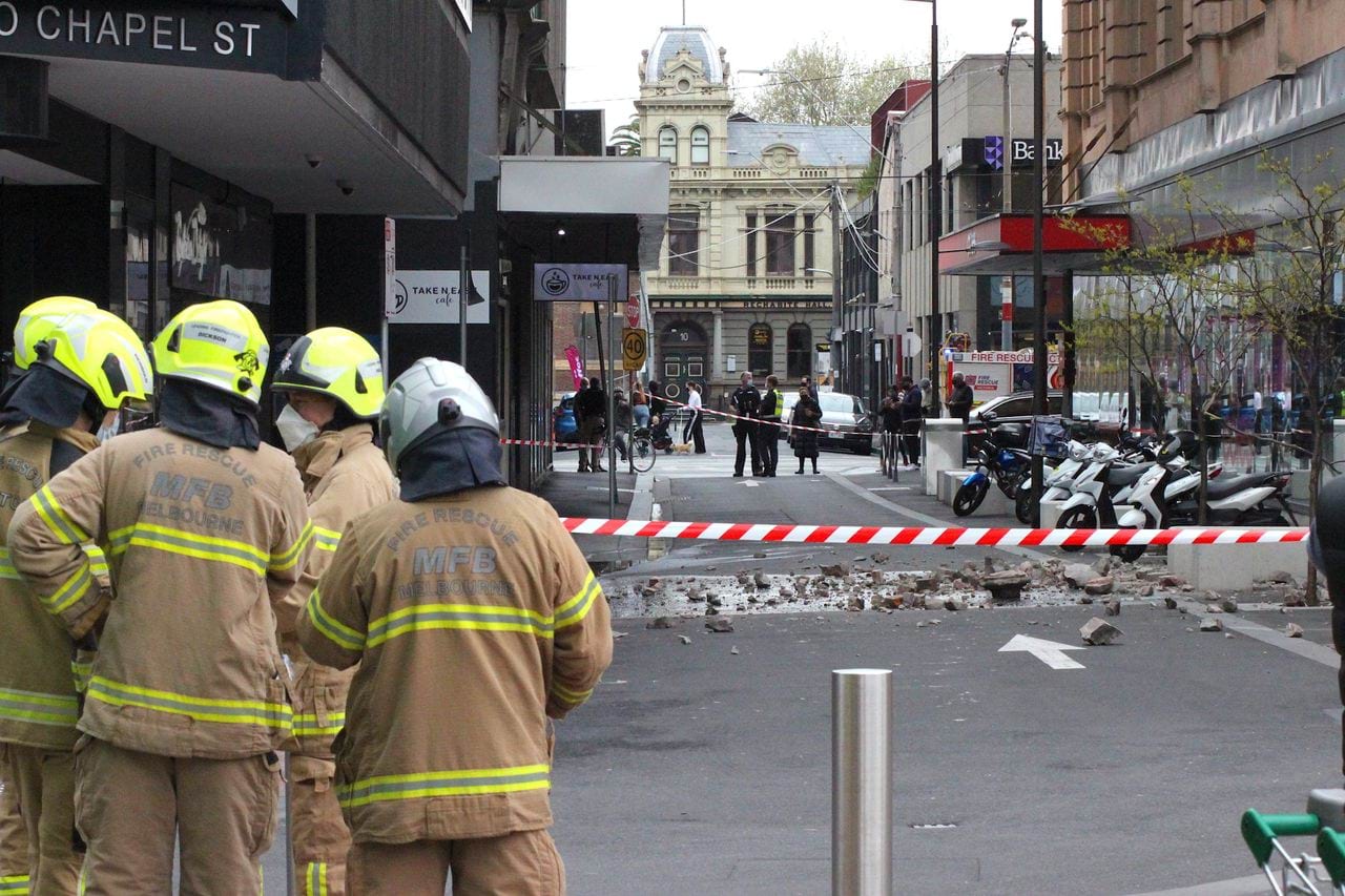
Retrofitting Melbourne’s buildings to withstand earthquakes
Cost-effective mitigation strategy development for building-related earthquake risk.

National Seismic Hazard Assessment (NSHA)
The NSHA defines the level of earthquake ground shaking across Australia, allowing higher hazard areas to be identified and mitigation strategies to be developed.

Earthquake Scenario Selector Tool
Query, visualise and download earthquake scenarios using pre-generated scenarios that represent plausible events that can be used for earthquake risk management and planning.