Subsurface sampling for stability: The importance of accuracy for safety and planning
Page last updated:14 March 2025
The Challenge
Civil engineering, infrastructure, construction, and mining projects are vital contributors to the Australian economy. The Mining and Construction sectors alone deliver an estimated 21.4 per cent of Australia’s GDP every year. Every construction begins with careful planning and preparation, which includes in situ sampling and testing. Accurate information about the physical and mechanical properties of the subsurface soil and rock is critical for regulators and decision makers.
Insitu Geotechnical Services (IGS) is an industry leader in high-quality in situ geotechnical testing and sampling services. Based in Brisbane, IGS provides over 50 per cent of ground investigation works across the Eastern seaboard, with operations that extend to all states and territories.
Global Navigation Satellite Systems (GNSS) are commonly used for locating, directing, and assisting machinery in geotechnical examinations. Without additional corrections, GNSS may only be accurate to within 5-10 metres.
IGS routinely conducts their work in hazardous and remote locations across Australia using specialised vehicles capable of operating in swamps, tailings dams, ponds, lakes, rivers, estuaries, and bays. Surveyors have traditionally been required on-site to assist with the sampling process, providing a precise record of location.
In late 2022, the Southern Positioning Augmentation Network (SouthPAN) was launched, providing real-time sub-metre accuracy to compatible GNSS devices anywhere in Australia or New Zealand. Using SouthPAN, IGS has improved their in-house capabilities, and are now providing a reliable and precise location for all sites, saving surveyors time and effort.
The Solution
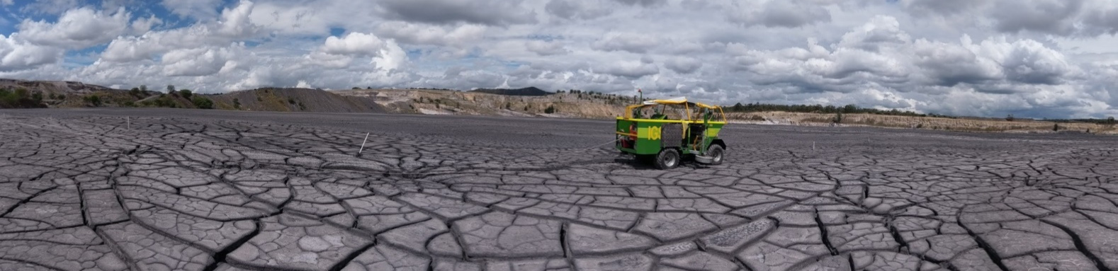
Mad Mack’ by IGS, a soft terrain rig operating remotely, in some of the most challenging onsite terrain.
SouthPAN is a joint initiative of the Australian and New Zealand Governments that provides Satellite-Based Augmentation System (SBAS) services for Australia and New Zealand. Geoscience Australia is working in partnership with Toitū Te Whenua Land Information New Zealand on the development, deployment, and operation of SouthPAN, the first open service SBAS in the Southern Hemisphere. SouthPAN offers sub-metre positioning accuracy; a significant improvement on the 5-10 metres available from standard GNSS. SouthPAN’s geostationary broadcast provides augmented and corrected satellite navigation signals directly from the satellite rather than through a cellular or internet connection. This allows sub-metre positioning to be available everywhere, overcoming gaps in mobile, internet and radio communications. SouthPANs early Open Services have been live since September 2022.
IGS completes upwards of 120 projects annually, utilising more than 15 purpose-built testing and sampling rigs, each equipped with a wide variety of sensing equipment, along with an EOS Arrow 100 GNSS receiver. EOS Arrow receivers support the SouthPAN L1 corrections service out-of-the-box, so users can enjoy greater positioning accuracy without requiring specialist training in GNSS systems. IGS field-crews are now able to locate are report test locations with higher precision, where previously a dedicated surveyor would have been required on-site.
A more precise record of the subsurface soil and rock properties assists IGS’ clients in facilitating safer and more efficient planning, design and construction. A deviation of just 5 metres in a sampling location can introduce significant risks for decision makers who rely on the accuracy of the models produced. Using SouthPAN, IGS can react to changing project requirements, collecting data wherever and whenever necessary, all with assured sub-metre accuracy.
The Impact
SouthPAN provides open access to real-time connectivity in remote areas, enhancing the accuracy and precision of GNSS devices. Users can benefit from SouthPAN’s open-access correction services, providing sub-metre positioning anywhere in Australia, New Zealand, and their maritime zones. With these new capabilities, IGS has been able to directly improve their services, reduce modelling uncertainty, save on costs, and provide better quality data to their clients and decision-makers. By equipping their teams with SouthPAN, IGS has been able to:
- Reduce the uncertainty of finding, marking, and testing locations from 5 meters down to sub-metre accuracy, creating more reliable datasets for their clients.
- Improve their team’s capabilities, allowing them to confidently tackle more difficult jobs that require sub-metre accuracy, such as modelling subsidence in urban areas.
- Save their clients tens of thousands of dollars or more by reducing the risk of undetected latent conditions through improved modelling resolution and preventing costly geotechnical investigations and rectifications.
- Reduce reliance on external surveyors for marking and pegging out test locations, streamlining their workflows and reducing downtime, further reducing costs to their clients.
- Access Australia-wide, real-time, open-source positioning, including in remote locations which traditionally required mobile internet.
- Minimised disturbances to surrounding ecosystems, contributing to environmental preservation and sustainable development efforts.
By adopting SouthPAN, IGS has enabled their team to collect better data, more efficiently, while improving the services delivered to their clients. SouthPAN provides IGS with a reliable method of achieving the accuracy that they require, capable of supporting projects anywhere in Australia, New Zealand and beyond.
SouthPAN helps us deliver on our mission to reduce geotechnical uncertainty.
Mark Chapman, Managing Director & Geotechnical Engineer, IGS