Appendix H - Map Boundaries / Extents Guide
1. Introduction
This appendix explains and defines the standard map extents to be used for published 1:250 000 and 1:100 000 scale maps. The appendix also details the geographical extents of adjusted maps sheets. Geographical extents for other adjusted (customised) map sheet extents not appearing in this appendix will be contained in the project file for the individual map unit/area.
2.Types of Extents
Standard sheet area: the standard sheet areas are 1o in latitude by 1o 30' in longitude for 1:250 000 and 30' in latitude by 30' in longitude for 1:100 000.

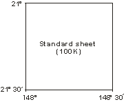
Bleed edge: A bleed edge exists for the 1:250 000 map, where the map is extended 3'to the north and 5' to the east. The bleed edge extensions are measured from the top right hand corner of the trimmed map. Unless otherwise specified the map extents will be the standard sheet area plus a bleed edge for the 1:250 000 product (only). No bleed edge exists for the 1:100 000 map.

Adjusted sheets: these sheets have been extended east-west and/or north-south, swung to a portrait format or displaced to eliminate maps which are largely sea area and to contain certain features on a single map. Adjusted map extent layout formats (guides) will be supplied as required.
Insets: Insets are used to display some islands and other offshore features which would not warrant production of a separate map.
3. Paper Sizes and Map Layouts
The table below details the trimmed paper sizes for 1:250 000 and 1:100 000 maps. All paper sizes fold down to the same size.
| Trim Size | Map layout codes |
|---|---|
| 800 x 500 mm | 1A |
| 900 x 500 mm | 1B |
| 1000 x 500 mm | 1C |
| 600 x 750 mm | 1D |
| 700 x 750 mm | 1E, 2E |
| 800 x 750 mm | 1F, 2F |
| 900 x 750 mm | 1G, 2G |
| 500 x 900 mm | 1H |
| 800 x 699 mm | 3A |
| 900 x 699 mm | 3B, 3C |
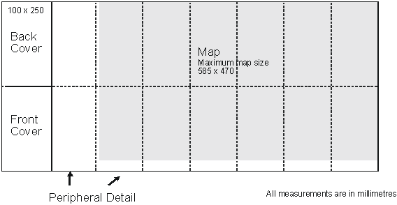
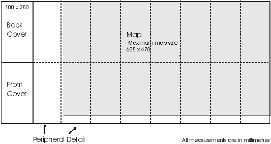
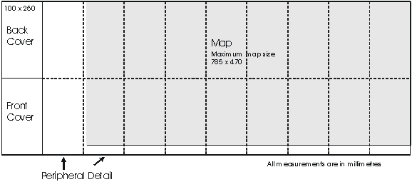
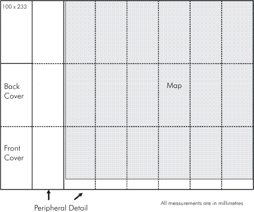
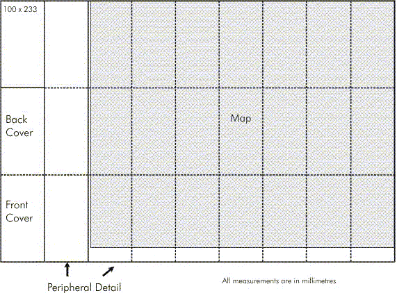
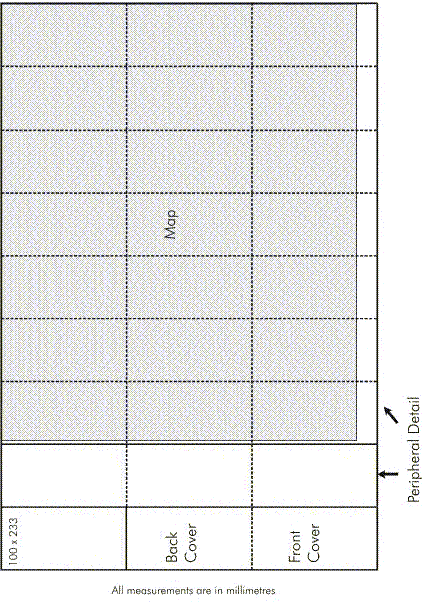
The following diagrams show the relationship of trimmed paper size to the number of folds and map extents and indicate the layout of information in the margin. The relationship to the detailed layout guides in Appendix B is also given together with any modifications due to trimmed paper size. The maximum printing area will extend 40 mm above the trim line at the top, 30 mm out from the trim line at the sides and 10 mm at the bottom. All registration marks, colour control and map bleed will fall within the maximum printing area.
Layout 1A :Trim size 800 x 500
Appendix B Landscape layout. Right hand end of scale bar to be 200 mm from eastern trim line
Layout 1B :Trim size 900 x 500
Appendix B Landscape layout. Right hand end of scale bar to be 250 mm from eastern trim line
Layout 1C :Trim size 1000 x 500
Appendix B Landscape layout. Right hand end of scale bar to be 300 mm from eastern trim line
Layout 1D :Trim size 600 x 750
Legend and other peripheral data as shown on guide to be issued when map is to be produced.
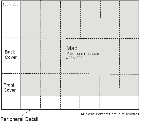
Layout 1E :Trim size 700 x 750
Legend and other peripheral data as shown on guide to be issued when map is to be produced.
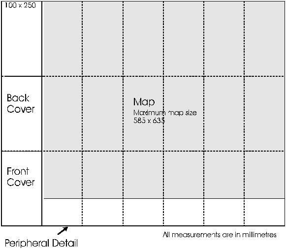
Layout 2E :Trim size 700 x 750
Appendix B Portrait layout. Right hand end of scale bar to be 150 mm from eastern trim line
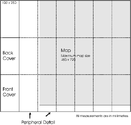
Layout 1F :Trim size 800 x 750
Appendix B Portrait layout. Right hand end of scale bar to be 200 mm from eastern trim line
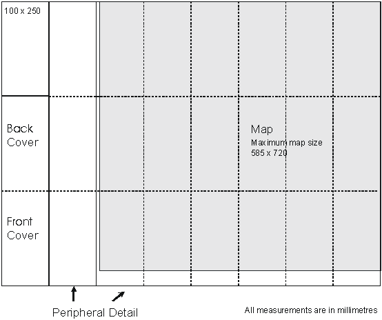
Layout 2F :Trim size 800 x 750
Legend and other peripheral data as shown on guide to be issued when map is to be produced.
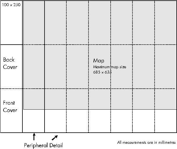
Layout 1G :Trim size 900 x 750
Appendix B Portrait layout. Right hand end of scale bar to be 250 mm from eastern trim line
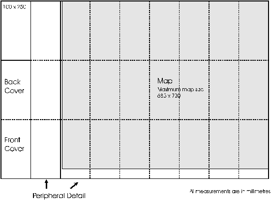
Layout 2G :Trim size 900 x 750
Legend and other peripheral data as shown on guide to be issued when map is to be produced.
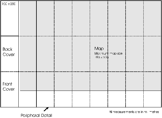
Layout 1H :Trim size 500 x 900
Legend and other peripheral data as shown on guide to be issued when map is to be produced.
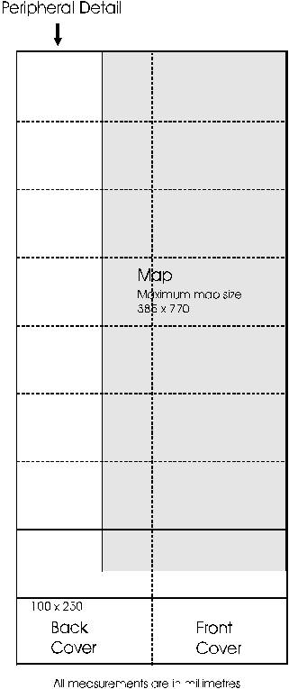
Layout 3A :Trim size 800 x 699
Layout 3B :Trim size 900 x 699
Layout 3C :Trim size 699 x 900
4. Layouts for unadjusted 1:100 000 sheets
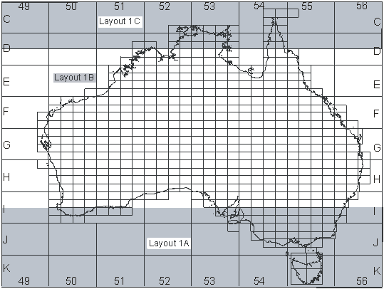
For all standard (unadjusted) 100K map sheets, the Map Layout Code will be 3A
5. Layouts for unadjusted 1:250 000 sheets
This index shows the layout for unadjusted maps. The table following this index indicates layouts for adjusted sheets. Appendix G shows both adjusted and unadjusted maps on the one index. Because the sheet extents are defined by geographicals and the distance along a parallel of latitude decreases away from the equator, the width of the map detail decreases going south hence the use of three sheet layouts for unadjusted maps.
6. 1:100 000 Adjusted Sheets
This table gives the extents for the map for adjusted 1:100 000 NTMS maps. The maps are in order by their number.
Custom 1:100 000 map extents not part of the NTMS series can be found in Chapter 8 1:100 000 Custom Sheets of this appendix.
Please Note: All latitudes in this table are in the Southern Hemisphere unless otherwise stated.
| 100K Map | Layout | MAP Coordinates | |||
|---|---|---|---|---|---|
| South West Geographic | North East Geographic | ||||
| 1446 Quoin Special | 3C | 26° 00' | 112° 30' | 25° 27' | 113° 00' |
| 1640 Abrolhos Special | 3A | 29° 00' | 113° 36' | 28° 30' | 114° 06' |
| 1644 Tamala Special | 3B | 27° 00' | 113° 24' | 26° 30' | 114° 00' |
| 1649 Macleod Special | 3B | 24° 30' | 113° 22' | 24° 00' | 114° 00' |
| 1650 Minilya Special | 3B | 24° 00' | 113° 22' | 23° 30' | 114° 00' |
| 1754 Exmouth Special | 3B | 22° 00' | 113° 54' | 21° 30' | 114° 30' |
| 1929 Leeuwin Special | 3A | 34° 30' | 114° 57' | 34° 00' | 115° 30' |
| 1930 Busselton Special | 3A | 34° 00' | 114° 57' | 33° 30' | 115° 30' |
| 1937 Hill River Special | 3B | 30° 30' | 114° 54' | 30° 00' | 115° 30' |
| 1938 Arrowsmith Special | 3B | 30° 00' | 114° 50' | 29° 30' | 115° 30' |
| 1957 Montebello Special | 3A | 20° 30' | 115° 15' | 20° 00' | 115° 45' |
| 2033 Fremantle Special | 3B | 32° 30' | 115° 24' | 32° 00' | 116° 00' |
| 2034 Perth Special | 3B | 32° 00' | 115° 24' | 31° 30' | 116° 00' |
| 2128 Northcliff Special | 3C | 35° 06' | 116° 00' | 34° 30' | 116° 30' |
| 2228 Deep River Special | 3C | 35° 06' | 116° 30' | 34° 30' | 117° 00' |
| 2328 Denmark Special | 3C | 35° 06' | 117° 00' | 34° 30' | 117° 30' |
| 2356 Roebourne Special | 3C | 21° 00' | 117° 00' | 20° 24' | 117° 30' |
| 2427 Albany Special | 3A | 35° 30' | 117° 30' | 35° 00' | 118° 06' |
| 2528 Manypeaks Special | 3A | 35° 02' | 118° 00' | 34° 30' | 118° 30' |
| 2729 Bremer Special | 3C | 34° 33' | 119° 00' | 34° 00' | 119° 30' |
| 2857 Pardoo Special | 3C | 20° 30' | 119° 30' | 19° 54' | 120° 00' |
| 2930 Ravensthorpe Special | 3C | 34° 06' | 120° 00' | 33° 30' | 120° 30' |
| 3030 Oldfield Special | 3C | 34° 06' | 120° 30' | 33° 30' | 121° 00' |
| 3260 Lagrange Special | 3C | 19° 00' | 121° 30' | 18° 23' | 122° 00' |
| 3566 Adele Special | 3C | 16° 00' | 123° 00' | 15° 24' | 123° 30' |
| 3630 Malcolm Special | 3B | 34° 00' | 123° 30' | 33° 30' | 124° 12' |
| 3932 Rockhole Special | 3B | 33° 00' | 125° 00' | 32° 30' | 125° 37' |
| 4534 Kuthala Pass Special | 3C | 32° 06' | 128° 00' | 31° 30' | 128° 30' |
| 4870 Dombey Special | 3C | 14° 00' | 129° 30' | 13° 24' | 130° 00' |
| 4971 Anson Special | 3B | 13° 30' | 129° 55' | 13° 00' | 130° 30' |
| 5475 Croker Special | 3A | 11° 30' | 132° 30' | 10° 57' | 133° 00' |
| 5732 Streaky Bay Special | 3B | 33°00' | 133°48' | 32°30' | 134°30' |
| 5830 Topgallant Special | 3B | 34°00' | 134°14' | 33°30' | 134°49' |
| 5873 Milingimbi Special | 3C | 12° 30' | 134° 30' | 11° 54' | 135° 00' |
| 5930 Sheringa Special | 3B | 34° 00' | 134° 49' | 33° 30' | 135° 30' |
| 6028 Lincoln Special | 3A | 35° 03' | 135° 30' | 34° 30' | 136° 00' |
| 6171 Blane Special | 3B | 13° 30' | 136° 00' | 13° 00' | 136° 36' |
| 6226 Borda Special | 3A | 36° 12' | 136° 30' | 35° 39' | 137° 00' |
| 6266 Pellew Special | 3A | 16° 00' | 136° 30' | 15° 27' | 137° 00' |
| 6272 Caledon Special | 3C | 13° 03' | 136° 30' | 12° 30' | 137° 00' |
| 6275 Marchinbar Special | 3B | 11° 30' | 136° 24' | 11° 00' | 137° 00' |
| 6325 Kersaint Special | 3B | 36° 30' | 137° 00' | 36° 00' | 137° 39' |
| 6328 Turton Special | 3B | 35° 00' | 136° 54' | 34° 30' | 137° 30' |
| 6429 Maitland Special | 3B | 34° 30' | 137° 18' | 34° 00' | 138° 00' |
| 6825 Santo Special | 3A | 36° 30' | 139° 27' | 36° 00' | 140° 00' |
| 6863 Sweers Island Special | 3A | 17° 30' | 139° 30' | 16° 56' | 140° 00' |
| 6864 Cape Van Diemen Special | 3A | 16° 45' | 139° 30' | 16° 15' | 140° 00' |
| 7022 Gambier Special | 3C | 38° 06' | 140° 30' | 37° 30' | 141° 00' |
| 7164 Macaroni Special | 3B | 17° 00' | 140° 57' | 16° 30' | 141° 30' |
| 7267 Mitchell River Special | 3B | 15° 30' | 141° 27' | 15° 00' | 142° 00' |
| 7270 Archer River Special | 3B | 14° 00' | 141° 27' | 13° 30' | 142° 00' |
| 7618 King Island Special | 3C | 40° 10' | 143° 48' | 39° 33' | 144° 11' |
| 7721 Geelong Special | 3C | 38° 33' | 144° 00' | 38° 00' | 144° 30' |
| 7815 Nelson Bay (Tas) | 3C | 41° 47' | 144° 30' | 41° 00' | 145° 00' |
| 7816 Hunter (Tas) | 3C | 41° 00' | 144° 20' | 40° 22' | 145° 00' |
| 7821 Sorrento Special | 3C | 38° 33' | 144° 30' | 38° 00' | 145° 00' |
| 7921 Western Port Special | 3C | 38° 36' | 145° 00' | 38° 00' | 145° 30' |
| 7965 Mossman Special | 3B | 16° 30' | 145° 00' | 16° 00' | 145° 36' |
| 7968 Cape Flattery Special | 3B | 15° 00' | 145° 00' | 14° 30' | 145° 33' |
| 8015 Inglis (Tas) | 3C | 41° 30' | 145° 30' | 40° 51' | 146° 00' |
| 8064 Cairns Special | 3B | 17° 00' | 145° 30' | 16° 30' | 146° 03' |
| 8162 Innisfail Special | 3B | 18° 00' | 146° 00' | 17° 30' | 146° 33' |
| 8163 Cooper Point Special | 3C | 17° 30' | 146° 00' | 16° 57' | 146° 30' |
| 8210 South Cape (Tas) | 3B | 43° 51' | 146° 00' | 43° 30' | 147° 02' |
| 8215 Tamar (Tas) | 3C | 41° 30' | 146° 30' | 40° 58' | 147° 00' |
| 8219 Curtis Special | 3A | 39° 33' | 146° 30' | 39° 00' | 147° 06' |
| 8220 Yarram Special | 3A | 39° 00' | 146° 30' | 38° 30' | 147° 03' |
| 8311 D'Entrecasteaux (Tas) | 3C | 43° 33' | 147° 00' | 43° 00' | 147°30' |
| 8315 Pipers (Tas) | 3C | 41° 30' | 147° 00' | 40° 49' | 147°30' |
| 8321 Sale Special | 3B | 38° 30' | 147° 00' | 38° 00' | 147°45' |
| 8411 Storm Bay (Tas) | 3B | 43° 30' | 147° 30' | 43° 00' | 148° 05' |
| 8458 Cape Upstart Special | 3A | 20° 00' | 147° 30' | 19° 27' | 148° 00' |
| 8657 Proserpine Special | 3A | 20° 30' | 148° 30' | 19° 57' | 149° 00' |
| 8823 Eden Special | 3B | 37° 30' | 149° 30' | 37° 00' | 150° 06' |
| 8824 Bega Special | 3B | 37° 00' | 149° 30' | 36° 30' | 150° 06' |
| 8856 Scawfell Special | 3B | 21° 00' | 149° 30' | 20° 30' | 150° 06' |
| 8954 Percy Isles Special | 3C | 22° 00' | 150° 00' | 21° 27' | 150° 30' |
| 9053 Peninsula Range Special | 3C | 22° 30' | 150° 30' | 21° 56' | 151° 00' |
| 9249 Miriam Vale Special | 3B | 24° 30' | 151° 30' | 23° 57' | 152° 06' |
| 9333 Bulahdelah Special | 3B | 32° 30' | 152° 00' | 32° 00' | 152° 36' |
| 9348 Bundaberg Special | 3A | 25° 00' | 152° 00' | 24° 30' | 152° 32' |
| 9435 Kempsey Special | 3B | 31° 30' | 152° 30' | 31° 00' | 153° 09' |
| 9436 Macksville Special | 3B | 31° 00' | 152° 30' | 30° 30' | 153° 09' |
| 9445 Gympie Special | 3B | 26° 30' | 152° 30' | 26° 00' | 153° 10' |
| 9540 Lismore Special | 3B | 29° 00' | 153° 00' | 28° 30' | 153° 39' |
| 9541 Murwillumbah Special | 3B | 28° 30' | 153° 00' | 28° 00' | 153° 40' |
| 9542 Beenleigh Special | 3A | 28° 00' | 153° 00' | 27° 30' | 153° 31' |
| 9542 Brisbane Special | 3B | 27° 30' | 153° 00' | 27° 00' | 153° 36' |
(1) 2758 Poissonnier will have a inset covering the spatial extent of 19°55'S 118°52'E to 19°51'S 118°56'E centred on 19°53'S 118°05'E (same alignment) containing North Turtle Island.
(2) 3869 Maret will have a inset covering the spatial extent of 14°09'S 123°30'E to 14°05'S 123°34'E centred on 14°07'S 124°36'E (same alignment) containing Browse Island.
(3) 5575 Arafura will have a inset covering the spatial extent of 10°55'30"S 133°01'E to 10°53'30"S 133°03'E centred on 11°04'30"S 133°06'E containing New Year Island.
(4) 5928 Wangary will have a inset covering the spatial extent of 34°50'S 134°41'E to 34°48'S 134°43'E centred on 34°49'S 135°05'E (same alignment) containing Rocky Island.
(5) 5928 Wangary will have a inset covering the spatial extent of 34°40'S 134°45'E to 34°37'S 134°49'E centred on 34°38'30"S 135°05'E (same alignment) containing Greenly Island.
(6) 9350 Hoskyn Island will have a inset covering the spatial extent of 24°08'S 152°41'E to 24°05'S 152°44'E centred on 23°57'30"S 152°26'E containing Lady Elliot Island.
(7) 8219 Curtis Special will have a inset covering the spatial extent of 39°33'S 147°07'E to 39°25'S 147°26'E containing Deal Island.
(8) 8315 Pipers will have a inset covering the spatial extent of 40°57'S 146°58'E to 40°56'S 146°59'30"E containing Tenth Island.
(9)There will be an overlap of detail in the SW corner of Anson Special with the NE corner of Dombey Special
(10)There will be an overlap of detail in the SW corner of Hoskyn Island with the N of Miriam Vale Special
(11)There will be an overlap of detail in the S of Rodds Bay with the N of Miriam Vale Special
(12)There will be an overlap of detail in the SE corner of Cairns Special with the NW corner of Cooper Point Special
(13)There will be an overlap of detail in the SW corner of Caledon Special with the NE corner of Blane Special
(14)There will be an overlap of detail in the SW corner of Manypeaks Special with the NE corner of Albany Special
(15)There will be an overlap of detail in the SW corner of D'Entrecasteaux with the NE corner of South Cape
(16)Tasmanian Adjusted Sheets have not had Special included as part of the name due to an attempt to align naming to state mapping.
7. 1:250 000 Adjusted Sheets
This table gives the map layout code and geographical extents for adjusted 1:250 000 maps. The maps are ordered by working clockwise around the coast starting from Melbourne
| 250K Map | Layout | MAP Coordinates | |||
|---|---|---|---|---|---|
| South West Geographic | North East Geographic | ||||
| SJ55-9 Port Phillip Special | 1F | 39° | 144° | 37°27' | 145°35' |
| SJ54-7 Hamilton Special | 1F | 38°30' | 141° | 36°57' | 142°35' |
| SJ54-6 Penola Special | 1F | 38°30' | 139°30' | 36°57' | 141°05' |
| SJ54-2 Naracoorte | 1B | 37° | 139°25' | 35°57' | 141°05' |
| SI54-9 Adelaide Special | 1F | 35°20 | 138° | 33°57' | 139°35' |
| SI53-12 Yorke Peninsula Special | 1F | 35°30' | 136°30' | 33°57' | 138°05' |
| SI53-16 Kangaroo Island Special | 1C | 36°30' | 136°30' | 35°27' | 138°25' |
| SI53-11 Lincoln Special | 1F | 35°25' | 135° | 33°57' | 136°35' |
| SI53-6 Elliston | 1B | 34°01' | 133°30 | 32°57' | 135°05' |
| SH52-14 Eucla Special | 1G | 32°20' | 127°30' | 30°57' | 129°05' |
| SH52-13 Madura Special | 1G | 32°20' | 126° | 30°57' | 127°35' |
| SI51-7 Malcolm Special | 1G | 34°30' | 123° | 32°57' | 124°35' |
| SI51-6 Esperance Special | 1G | 34°30' | 121°30 | 32°57' | 123°05' |
| SI50-11 Mount Barker Special | 1F | 35°30' | 117° | 33°57' | 118°35' |
| SI50-10 Pemberton Special | 1F | 35°30' | 115°30' | 33°57' | 117°05' |
| SI50-5 Busselton Special (1) | v | 34°27 | 114°35' | 33°24' | 115°35' |
| SI50-2 Pinjarra | 1B | 33° | 115°18' | 31°57' | 117°05' |
| SH50-14 Perth Special | 1G | 32°30' | 115°18' | 30°57' | 117°05' |
| SH50-1 Geraldton Special | 1C | 29° | 113°34 | 27°57' | 115°33' |
| SG50-13 Ajana | 1C | 28° | 113°48' | 26°57' | 115°35' |
| SG49-12 Monkey Mia Special | 2E | 27° | 112°53' | 25°27' | 114°05' |
| SG49-4 Carnarvon Special | 2E | 25°30' | 112°55 | 23°57' | 114°05' |
| SF49-16 Minilya Special | 1H | 24° | 113°10' | 22°17' | 114°05' |
| SF50-9 Yanrey Special | 1C | 23° | 113°45' | 21°57' | 115°35' |
| SF50-5 Onslow | 1C | 22° | 113°54' | 20°57' | 115°35 |
| SF50-2 Dampier Special | 1C | 21° | 115°15' | 19°57' | 117°05' |
| SF50-4 Port Hedland Special | 1G | 21° | 118°30' | 19°27' | 120°05' |
| SD51-15 Camden Sound Special (2) | 1B | 16° | 123° | 14°57' | 124°35' |
| SD51-12 Montague Sound Special | 1G | 15° | 124°30' | 13°27' | 126°04' |
| SD52-7 Cape Scott Special | 2E | 14° | 129°30' | 12°27' | 130°35' |
| SC52-16 Melville Island Special | 1C | 12° | 130° | 10°57' | 131°47 |
| SC53-13 Cobourg Peninsula Special | 1C | 12° | 131°45' | 10°57' | 133°30' |
| SD53-2 Milingimbi Special | 2G | 13° | 133°25' | 11°40' | 135°05' |
| SD53-3 Galiwinku Special | 2E | 13° | 135° | 11°27' | 136°05' |
| SC53-16 Wessel Islands Special | 1C | 12° | 136° | 10°57' | 137°35' |
| SD53-4 Gove Peninsula Special | 1C | 13° | 136° | 11°57' | 137°35' |
| SD53-8 Groote Eylandt Special | 2E | 14°30' | 136° | 12°57' | 137°05' |
| SE53-4 Robinson River Special | 1G | 17° | 136°30' | 15°27' | 138°05' |
| SE54-1 Mornington Island Special (3) | 1C | 17° | 138° | 15°57' | 139 45' |
| SE54-6 Burketown | 1B | 18° | 139°30' | 16°57' | 141°05' |
| SD54-11 Holroyd Special | 1F | 15° | 141°25' | 13°27' | 142°35' |
| SD54-3 Weipa Special | 2E | 13°30' | 141°30' | 11°57' | 142°35' |
| SG56-3 Fraser Island Special | 2E | 26° | 152°30' | 24°27' | 153°35 |
| SG56-10 Gympie | 1B | 27° | 151°30' | 25°57' | 153°12' |
| SG56-15 Brisbane Special | 2E | 28°30' | 152°53' | 26°57' | 154°05' |
| SH56-7 Lismore Special | 2E | 30° | 153° | 28°27' | 154°05' |
| SH56-10 Armidale Special | 1B | 31° | 151°30' | 29°57' | 153°17' |
| SH56-14 Hastings | 1B | 32° | 151°30 | 30°57' | 153°05' |
| SI56-5 Sydney Special | 1G | 34°30' | 150° | 32°57' | 151°45' |
| SI56-13 Wollongong Special | 1H | 36° | 150° | 34°17' | 151°02' |
| SJ55-4 Bega | 1B | 37° | 148°30' | 35°57' | 150°15' |
| SJ55-8 Mallacoota | 1A | 38° | 148°30' | 36°57' | 150°05' |
| SJ55 -7 Bairnsdale Special | 1F | 38°33' | 147° | 36°57' | 148°35' |
| SJ55-10 Warragul Special (4) | 1F | 39°32' | 145°30' | 37°57' | 147°05' |
| SK55 -1 King Island Special (5) | 1C | 41° | 143°45' | 39°56' | 145°48' |
| SK55 - 3 Flinders Island Special | 1F | 41° | 147° | 39°23' | 148°36' |
| SK55 -6 Burnie | 1C | 42° | 144°30' | 40°56' | 146°36' |
| SK55 -7 Launceston | 1C | 42° | 146°30' | 40°56' | 148°36' |
| SK55 -10 Queenstown | 1C | 43° | 145° | 41°56' | 147°06' |
| SK55 -11 Hobart Special | 1F | 43°33' | 147° | 41°56' | 148°26' |
| SK55 -14 Port Davey | 1A | 44° | 145°30' | 42°56' | 147°06' |
(1) SI5005 Busselton Special - individual layout.
(2) SD5115 Camden Sound Special the area 14°10' 123°30' to 14° 123°38' covering Browse Island will be inset to the map.
(3) SE5401 Mornington Island Special the area 16°45' 139°45' to 16°25' 139°55' covering the Bountiful Islands will be inset to the map.
(4) SJ5510 Warragul Special the area 39°32' 147°05' to 39°25' 147°25' covering Deal Island will be inset to the map.
(4) SK5501 King Island Special the area 40°12' 143°48' to 39°33' 144°11' covering King Island will be inset to the map.
8. 1:100 000 Custom Sheets
This table gives the extents for the map for Custom 1:100 000 maps. These maps are not part of the standard NTMS series but have been developed for specific purposes eg Fire Management, Custom National Park Mapping. These maps are numbered with a 'CUS' prefix in the 100K index to denote there status.
Please Note: All latitudes in this table are in the Southern Hemisphere unless otherwise stated.
Please Note: All Coordinates in this table are in the geographic unless MGA Zone is specified.
Please Note: Layouts have not been specified as they are custom designed, layout design will be provided (when required) at discretion of Geoscience Australia.
| 100K Map | MGA Zone | MAP Coordinates | |||
|---|---|---|---|---|---|
| South West Geographic | North East Geographic | ||||
| CUS0001 ACT Region | MGA 55 | 6018000mN | 648000mE | 6115000mN | 724000mE |
| CUS0002 Karijini National Park | MGA 50 | 7486000mN | 597000mE | 7549000mN | 680000mE |
| CUS0003 West MacDonnell National Park (Map 1) | 24° 00' | 132° 15' | 23° 26' | 133° 03' | |
| CUS0003 West MacDonnell National Park (Map 2) | 24° 00' | 133° 00' | 23° 26' | 133° 57' | |
| CUS0004 Uluru - Kata Tjuta National Park | 25° 27' | 130° 38' | 24° 53' | 131° 27' | |
| CUS0005 Watarrka National Park | 24° 29' | 131° 20' | 24° 06' | 131° 57' | |
| CUS0006 Carnarvon National Park | Map design with various extents windows | ||||
9. 1:250 000 Custom Sheets
This table gives the extents for the map for Custom 1:250 000 maps. These maps are not part of the standard NTMS series but have been developed for specific purposes eg Fire Management, Custom National Park Mapping. These maps are numbered with a 'CUS' prefix in the 250K index to denote there status.
Please Note: All latitudes in this table are in the Southern Hemisphere unless otherwise stated.
Please Note: All Coordinates in this table are in the geographic unless MGA Zone is specified.
Please Note: Layouts have not been specified as they are custom designed, layout design will be provided (when required) at discretion of Geoscience Australia.
| 250K Map | MGA Zone | MAP Coordinates | |||
|---|---|---|---|---|---|
| South West Geographic | North East Geographic | ||||
| CUS0001 Shark Bay | 26° 45' | 112° 53' | 24° 35' | 114° 30' | |
Topic contact: mapfeedback@ga.gov.au Last updated: January 20, 2012
